Mount Lady MacDonald
(posted July 2025)

(posted July 2025)
Above: An evening Halloween snap along Lady M's upper ridge from a few years back. A brief squall had cleared just enough for me to get this shot, just before heading down.
Lady M is a regular haunt: in the 90s, through the mid- to late teens and, apparently, now. I'm typically out on two or three hikes like these each week and since early June, they've all been up here.
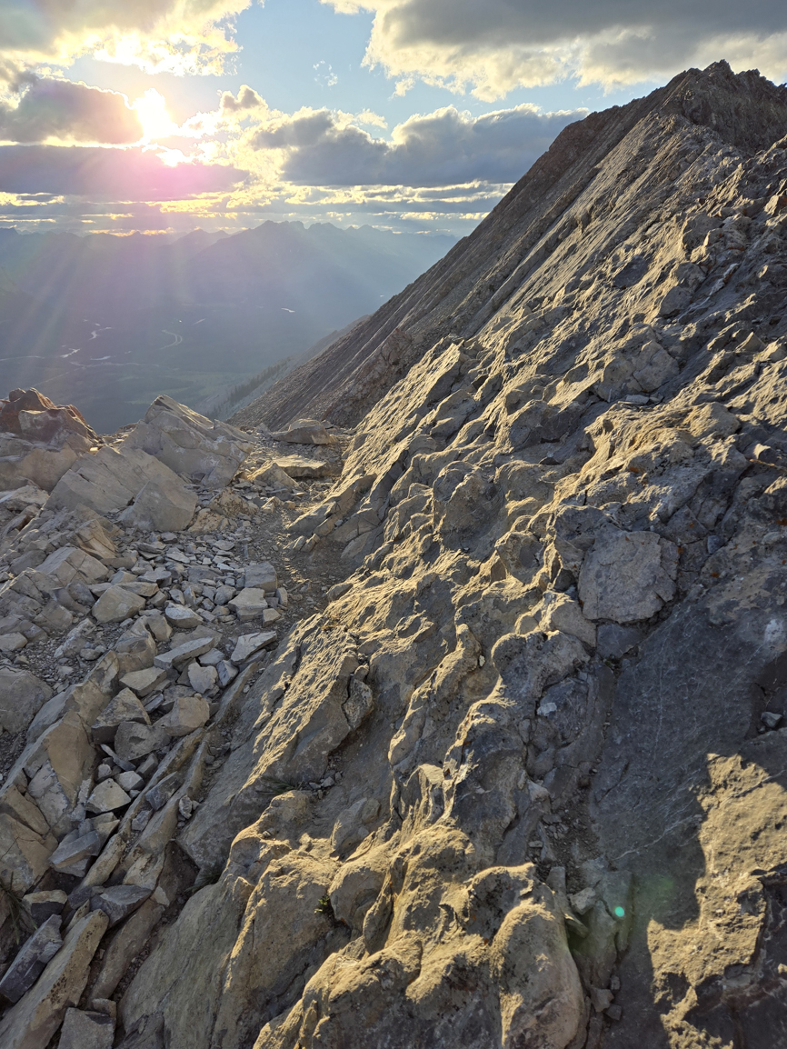
I’ve been up here by two routes: the popular south ridge route from town that works its way up a well-used trail just west of the south ridge to the tree line, then gains the south ridge itself until it joins the southeast ridge (this post's first two shots) to reach the summit. It's well known, well marked and well used. Until June of this year (2025), this was my usual route.
The southeast ridge route follows Cougar Creek another 1.8km from the new dam, then leaves the creek as a steep, light trail marked with cairns (2025) to gain the southeast ridge earlier and lower than where the more popular route joins this same ridge. Shortly after leaving the creek the southeast ridge "route" becomes more of a collection of options than a single well-defined trail. These options include third class scrambling along long rock walls that grow to towering vertical cliffbands on your left as you climb. Or routes that push to stay on top of them and keep the ridgelines.
After a half-dozen ascents or so over the last few weeks, I’ve landed on a ridgeline option with a set of fifth-class options about ¾ hr past where the trail leaves Cougar Creek and another set that gains the upper ridgeline from its rock wall. There's some consensus in a 5.4 to 5.5 rating for this route2 and I think it's a good fit. Scrambling along, rather than on top of the rock walls only avoids the fifth class until the upper ridgeline, the actual southeast ridge.
I couldn’t find anything easier than mid-fifth to gain the upper ridgeline. My first few ascents used a short, steep slab (1850 6402). A few dozen meters further along the same wall, the ridge takes a sharp turn west at a nose feature (1845 6408). This feature looks like another decent mid-fifth option to gain the ridge, though the choice involves more sustained free-climbing out onto the steep and exposed north face.
I can just see the Kananaskis Public Safety people standing over my twisted, broken body, smashed to a bloody pulp along the bottom of that face. “Did this guy try climbing it in his approach shoes?”
Can't have that. Not the look I'm after.
I’d heard about a crack option at the other end of the ridge from a trailrunner (thanks to Charlie Sanderson) I met on the route. I've been through twice, once chased by looming thunderheads though I was able to get some nice shots with better skies my second time through. It’s still mid-fifth, but it’s more typical hand and foot placement climbing than just a slab move. It’s adds distance to the slab option but the scrambling is sublime. Even spiritual.
On gaining the ridge, it's all third with one fourth class step at the last rock wall before joining the popular south ridge trail, with several sections of prolonged, dizzying exposure. Whether said "dizzying exposure" is a good thing, gentle reader, is on you. If you're OK scrambling mid fifth and have no problem with the popular scramble's last airy and exposed traverse to the summit, you should be fine here. Otherwise, consider packing a rope and enough know-how for a whence-you-came retreat.

Yep, that's it. Spooky stuff!
(maybe even spookier than the Halloween title shot?)
It’s a moody, evening summit snap (above) from a few years back, cropped from a larger summit pan. If you can excuse the grain, it's a superb view of the southeast ridge as it works its way up from the lower left of the frame and traverses the shot. The more popular hike joins the ridge just above Lady MacDonald's summit cairn (right) from a scree bash out of sight on the far side. The nose-feature option I’d mentioned earlier, together with its fall hazard, drop out of the frame (and hundreds of meters, hence my hesitation in free-climbing it) on the left. The short slab and other nearby options are also on the opposite side of the ridge proper and out of sight, though we can see where they top out onto the ridge just a little further up from the nose.
This next shot should help knock some punch out of that panic...

Doesn’t look so bad from here, does it?
The sunny smiles and summer sun warm the view, snapped near where the nose drops out of the left frame of the previous shot.
Allow me to introduce Megan and Steve. I met them near the trailhead and had the singular pleasure of their company on an ascent. They're fit, fast, friendly, and they both climb exceptionally well! Steve was kind enough to snap some shots of your scrambling scribbler, which I've included further down.
As for the rest of this route, it's third class from here, with (maybe) a fourth class step at the last wall at the top of this shot, though old-school climbers might say it's still third. That wall, behind Steve on his right / your left, looks worse from here than it is.
Sections of this ridge have the same “au cheval” exposure as the more popular trail’s traverse to the summit, just much more of it. It’s the same ridge and earns Mr. Kane’s difficult rating in his guide1.
If you’re not comfortable with that section of the more popular scrambling route, including one step just a few dozen meters from the summit, you could be in a little over your head here. Fortunately, the rock wall along the southeast ridge would likely have turned you back already.
If it's your first time through, I'd suggest packing a rope so you can rap yourself out of a tight spot.
Now let's head back to town. I'll yap about the approach.
Head for the hills along Cougar Creek from town (for both hikes). The new dam is just visible through the trees around the bend.

A quick peek back across Cougar Creek (more of an aquaduct after the town's recent flood mitigation work) at Canmore's iconic trio.
(an obligatory shot)


Snapped from the top of the new dam. Signage is for Cougar Creek where this trail forked away from the popular hiking trail up the south ridge.
Side note: I could say it was easier to connect Lady M to Grotto’s west ridge before the damn dam. Now we need to descend the dam and run south along the creek another 300 m or so to cross, only to turn around and regain the elevation as soon as we hit the trail.
Damn!
or...
A more “hop the fence” mentality might be inclined to continue across the dam to the end of the road-like ledge on the right and scramble the short section up the bank, while cautioning that the scramble up the bank, though short, is super-chossy and starts high enough up the wall to have a painful slip penalty.
Should one be so inclined.
(ahem.)

Hahaha... My first crack at AI. I used Google's image generator.
Would you believe, some folks say I'm not funny?
Still, she's fit. But can she climb? Glacier camping on big ski trips? Or does she need a five-star hotel all the time.
She looks like she needs the hotel. I already have a girlfriend like that.
And what about the alpine starts? That makeup's gonna want at least an hour. I'd have to put my foot down on that.
Otherwise, maybe it could work...

Here's the non-AI (and cougarless) Cougar Creek, with Cougar Mountain in the background.
There's a plethora of short sport and trad climb routes along the way, peppered with locals on good days. Otherwise, the scene doesn't change much for the next 1.8 km to the trailhead.

We're after the right side of one of the features on the skyline. I'm not sure which one, though this trailhead is visible from up there. I'll come back with a fix if I figure it out.
One of them is our end of the southeast ridge. We want to gain its rock wall from the (viewer's) right.
Our trail moves up past two cairns into the forested rise on the right. Just one cairn is visible in this early July 2025 shot. Another is hiding behind a tree.
Before long, it’s clear there are several trails. It’s not always clear whether a trail is more for hoof- and paw than foot traffic, if that matters.

Two cairns are visible (July 2025), I think I saw a third had popped up my last time through. Keep 'em coming! (gives the cairn karens something to whine about 😁)
There is trail on the right.

Any route up the southeast ridge wants (nearly) the same elevation gain to the summit as the south ridge hike (we pick up a modest 70m along the creek from the dam base to the trailhead), but with the distance chopped in half. That math steepens this route considerably.
This ascent is steep!

We'll pause at this grove of limber pine.
Do we hike on top of, or alongside the rock walls?
I've hiked both. They're different experiences. I prefer to stick to the ridgelines: quicker ascent, spicier, little or no rockfall risk.
The ridgelines option has a fifth class step to gain the second ridgeline when it springs up 45 minutes hiking from the trailhead at Cougar Creek (1884 6332). I beefed up a cairn at the easiest of several choices I’ve found, though I suspect a more exhaustive search could turn up something easier (July 2025).
Much of this stuff is stacked choss, some of it held together with dried mud, though there’s enough passable rock for a cautious ascent. Yet the worst rock can look like the best placements and holds here. Watch out for that.
Test holds & placements before committing, & smaller crimps/holds are generally safer here.

I outlined the cairn so it shows against the rock wall in this shot. Otherwise it looks like part of the wall.

The view from up top. It's short, but it's steep. A slip would hurt!

The rock up top is suddenly superb! Flat runs of what looks like broken charcoal (obsidian?) embedded in decent (sedimentary?) rock. You could dyno off this stuff!
There’s a wall of the last shot's obsidian-embedded rock (or whatever it is) as another ascent option a few dozen meters up from the cairn, though it’s just as steep and much more prolonged (5.5 for higher stakes, pickier foot placements & crimpy holds). Technically tougher, but much better rock. I’ve done it in a technical- and climbing shoe. Not with my approach shoe.

The famed "Three Sisters" emerge over Grotto's shoulder, seen from Lady M's Southeast Ridge route.

(...and crux!)

Subtler route concessions and often more pronounced trail encourage you to the right of the growing rock walls, lengthening the route but taking some of the punch out of the steep ascent. You might like that.


Whether you run along or on top of the ridgelines, they all land up here along the long rock wall that forms Lady MacDonald's visible and pronounced backbone: her southeast ridge. There are several options, though I couldn't find anything easier than mid-fifth to gain the ridgeline from its wall.
I've included two of the easiest options I could find.
This short slab wall (below) was the first option I used. It's steep, but it's quick.

Megan doesn't seem too concerned about this slab.

Steve said he has poor footwork. I disagree.


Instead of the goofy pack, I could have shouldered a longbow or my Mossberg pump for Steve's cool snap with my Walmart camo hoodie! 😁
(...though I might have run into trouble trying to pack either through town on the ascent. Perhaps moreso with that hoodie)
I’m in my tech shoes (La Sportiva Trango Tech), they really shine on this slab and with technical terrain in general, even several resoles in. Just love ‘em, scrambled a pile of 11Kers in these things: Deltaform, Hungabee, Alberta, several trips up & down Assiniboine’s north ridge & south face among other ascents.
Across the pond, I scrambled up to the Solvay Hut in them, though the sole wasn’t quite stiff enough to take the crampon I used when I tackled that particular summit two days before. A strap crampon or even spikes would have went fine with this boot but I didn't know what I was up against & opted to play it safe.
As much as it shines in technical terrain, this shoe just isn’t built for running. Descending this route's return (Lady M’s easy south ridge hike) is hell at anything faster than a walk.

Blue skies today! The threat of inclement weather chased me up this crack two days before, my first time through.
I’d been running back and forth along this long rock wall looking for an easy crack ascent, easier than the short but steep slab I’d been using closer to the other end. The location fit a trailrunner’s description I’d met on the same route two days before (scroll down for some shots of Charlie Sanderson below, thanks Charlie!)
Yet Charlie had said it was on-par with another wall we’d just climbed, the last wall that tops out where this route joins the popular hike. I’ve got shots of that wall from a few different trips through there, including one with Charlie and Del, and accusing that wall of anything more than fourth class is a stretch. Not so here. This wall is much steeper and more sustained climbing, and with a nasty slip penalty.
Definitely healthy mid-fifth class stuff!
The sky had grown ominous in the last hour and with the forecasted thunderstorm watch, I opted to leave the crack for another day. Maybe I’d have a better shot at chasing a regular through here on a weekend, and with clear skies. I was just about to throw in the towel, head up to the slab I’d been using and complete the climb when another trailrunner appeared along the wall.
“I’m looking for a climbable crack somewhere nearby. Am I close?”
“You’re just about on it” he answered.

The view from the crack's base. Steep!! But the rock quality's OK lower down and gets better from there.
I stepped back to let him through.
"Thanks!"
By the time I lobbed the "you're welcome" he was halfway up the face.
In his trailrunners.
So that WAS the crack I was looking for!
I hadn’t expected it in the realm of a “trail run”.
But why not?
I do the same thing on Yam (Mount Yamnuska) and Assiniboine's north ridge. I regularly scramble lower fifth class trad routes on both, Yam in trail shoes. It would look more impressive than it should: I’ve been through enough times that the moves are all hammered into muscle-memory.
In that sense, this crack is no different.
It’s mid-fifth, but the rock quality improves from passable (watch for breakaway lower down) with the ascent. It tops out onto the base of a steep, narrow and exposed arete, also mid-fifth, with good rock.

Our arete, snapped from a small deck up top the crack feature. The skies were more accommodating than my first trip through here two days before, when incoming weather added incentive!
The occasional hanger or bolt on the arete was reassuring: they wouldn't have been there if it wasn't a regular route. It was my first time through and at least I knew I wasn't chasing some wishful thinking I’d have to downclimb just ahead of a thunderstorm.
This route hasn't yet had enough traffic for the telltale boot scuffs and scratches to show up.
A small plateau just a few meters' scramble up from where the slab tops out makes a nice spot for a break.


The shot foreshortens this feature: it’s taller and further away than it looks. It climbs (red arrows in the shot) easier than the slab. I did it in my approach shoes, no problem, where I prefer a technical- or climbing shoe for the slab. (I'm starting to think I need an approach shoe that does a little better on rock)
It's still fifth class: it has an overhanging element and more “pull down, not out” rock quality (a Canadian Rockies staple).
Just add water for instant suck (lichen!)
Traverse this ledge (green) to your right for an easier switchback option.
A quick look back at the arete (three shots back) from the base of the overhang feature. I'd met the two climbers at the crack (crux).


It's variations on this theme all the way up to the last rock wall on this ridge, then again for the 300m traverse to the summit after the south ridge (and its trail) join this ridge. It's all third class to that last rock wall, with plenty of opportunity for forays into more challenging terrain.

Above: A look back from partway along the upper ridge, with Grotto and its subsidiary in the background.
Thanks to Steve Anderson for this superbly framed capture of Megan & me on the ridge. If you like the more popular south ridge hike's ridge traverse to the summit, you'll like this one too. (It's the same ridge)

Charlie & Del on the ridge. Charlie gave me the beta for the crack-ascent option to gain this ridge at its far south end. (Thanks man!)


Charlie tops out a fifth class, no-fall section of the ridge (it's a long way down! An easier & lower-stake alternative is just out of the frame to the right). Check out his footwear: trail shoes!
It's incredible what folks are calling a "trail run" these days!


Nearing the ridgeline's last wall (left), the face angle eases and holds onto enough scree for a trail to emerge.

Views overlooking Canmore and the Bow Valley are spectacular all the way to the base of the wall.

It looks tough right up until you're on it. Then it's not so bad.

Some might say this one step on the last wall nudges it out of third class.
(but fifth is a stretch. Settle on fourth?)

The south ridge joins our ridge here, up top the ridge's last rock wall. The popular hiking trail is on the skyline (hiker just visible, center frame below) and merges with ours just a little further up this scree ramp.

An evening snap.
Steve is pointing out that it's a quick traverse from here to join the hiking trail for the hike down. He and Megan (just out of the frame to the right) plan to descend.

Salut les Québecois !
Snapped near the same position as the last shot, but closer to the ridgeline and earlier in the day. They're a group of friends from Québec, enjoying the hike.
The two routes join here, up top Lady MacDonald’s “false summit”.
For those of us who arrived by the southeast ridge route, The last stretch to the summit (poking up with more sun on it, just to our left / Mathilde’s right) is more of the same third class, exposed southeast ridgeline.

That’s for those of us who arrived here from the southeast ridge route.
Folks who arrive here from the popular south ridge hike will see this last traverse as an abrupt departure from the hiking domain onto the more technical and exposed...

Above: Hiker & cairn just visible on the summit.


The tricky spot's just between our climbing pair (same pair I met at the crux and snapped on the arete) and Mathilde (whom we met three shots back, at the ridge junction). It's more about being brutally exposed than technically difficult.
Mount Lougheed's three peaks and Wind Mountain3 are on the skyline directly above.
Below: Mount Lady MacDonald's summit ridgeline, the town of Canmore and the Bow Valley seen from her summit.


I first met Mathilde up top the ridge junction a few shots back where I encouraged her to try for the summit.
Her smile says it was worth a shot!
The snap's title comes from Mr. Kane's description of this very section of this very scramble in his very first edition.1
Below: the original summit shot (2019) I cropped for the Southeast ridge section's shot


Snapped along the south ridge from the ridge intersection

Snapped descending Lady M's south ridge.


He tripped trying to step over the rock on the left, then took a hard, awkward tumble into the bush. I thought he was hurt. Of all of us -- myself and his party -- his dog's concern was the most immediate.
When the smile spread across the owner's face and he started chuckling, we all knew he was OK. It didn't start well, but ended up being a pleasant moment.
Pretty sure that's what this thing is. It was here on my first ascent of this rock back in 1994, together with a helipad and another deck that were part of an incomplete teahouse. This ramp is still up here (2025). Everything else is gone.


Snapped in 2016, the helipad was still up here but the teahouse platform had been removed in 2013.
I wish I’d snapped it back in the ‘90s when I was up here but I didn’t own a camera then. No such thing as GPS and cellphones were just coming in. I didn’t have one.
The Mount Lady MacDonald Scramble was among the first in a pile of scrambles I hit with friends from the first edition of what was, and still is the region's scrambling bible, Mr. Kane's "Scrambles in the Canadian Rockies"1, not long after it was published. We didn't summit then: a wall of snow on this face forced a return return trip.
Salient memories include a woman in a dazzling wedding gown. A buddy and I had just gained the shoulder and I was dumbfounded. How had she managed to keep herself and her gown so clean after the gruelling climb up from town?
I’m glad I kept my wondering to myself and hope I’m at least a little smarter since then.
A helicopter had flown her party up and they held the ceremony on the shoulder on a separate deck which had already been removed when I snapped this shot, all part of an abandoned teahouse project.
There’s a new wooden bench (next shot) where the helipad sat until it was removed in 2022. The rest of the project had already been removed in 2013.
None of it remains today.
Below: What better way to wrap up this post than with a Bow Valley sunset bench shot?
Snapped from the new wooden bench on top of the much older geological bench at the foot of the scree ramp to the intersection of Lady M's south and southeast ridges. I snapped this one in July of 2025.
