Lougheed Traverse
Towers 1, 2 and 3
(2016 thru 2023)
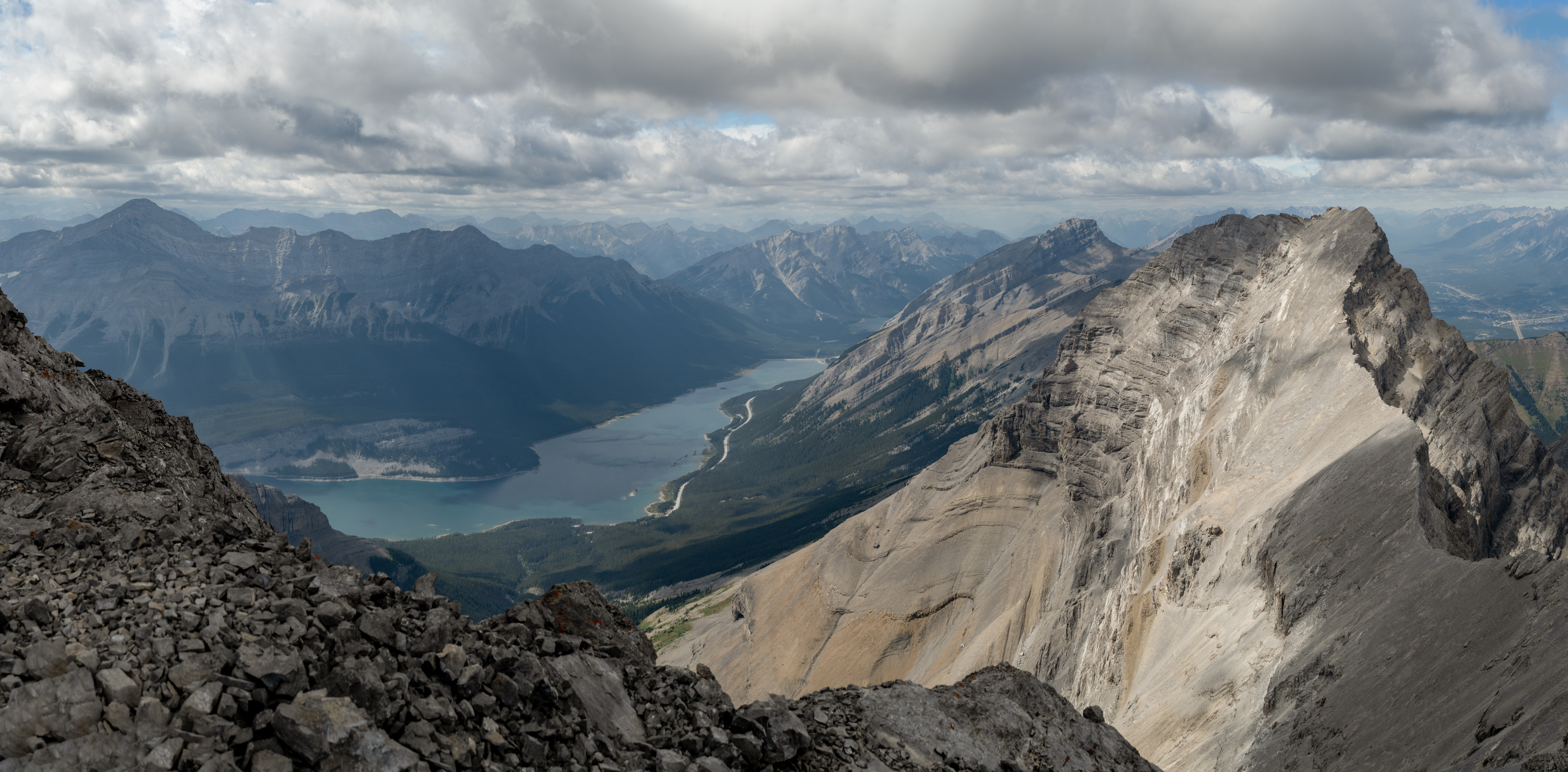
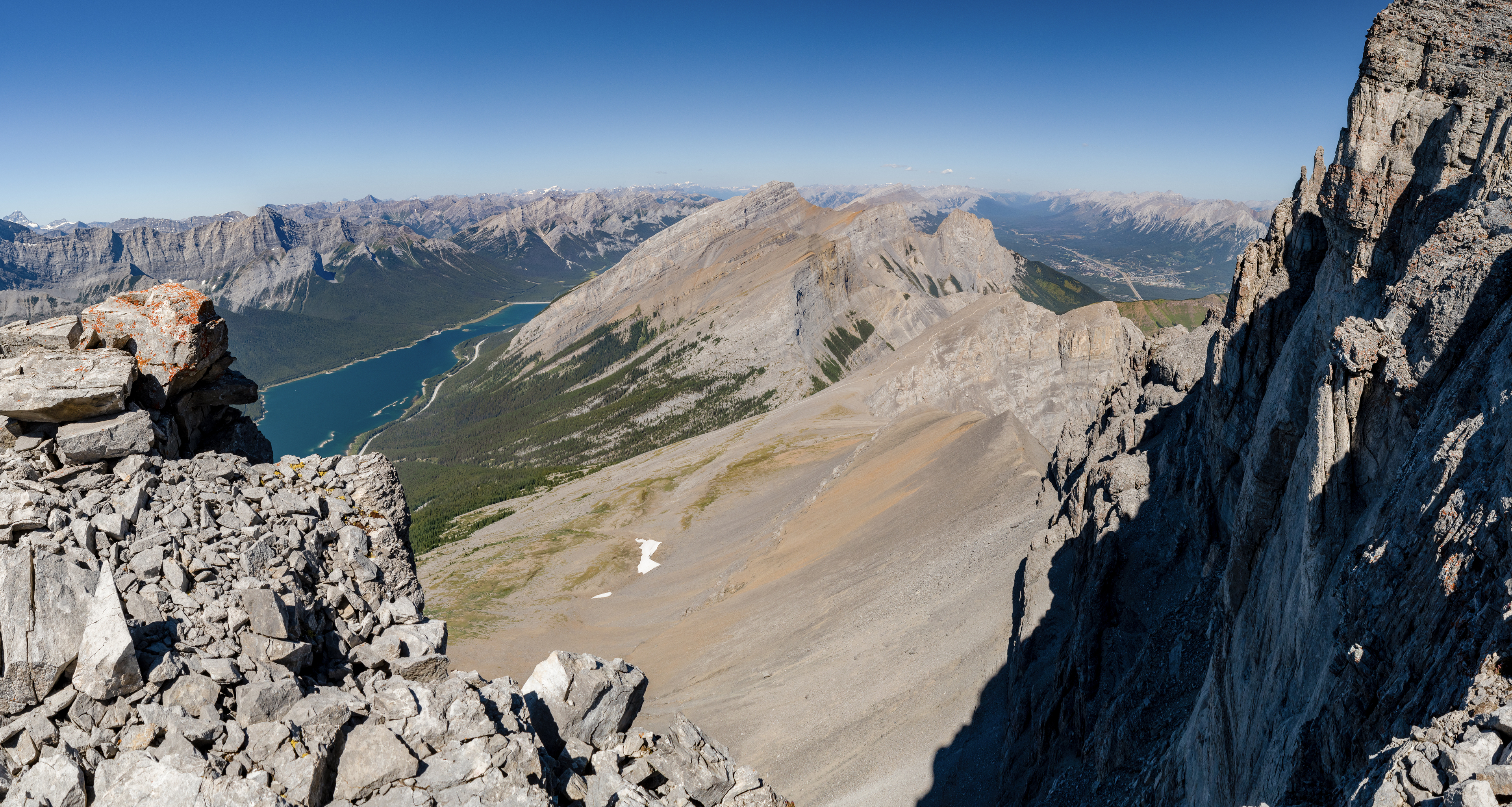
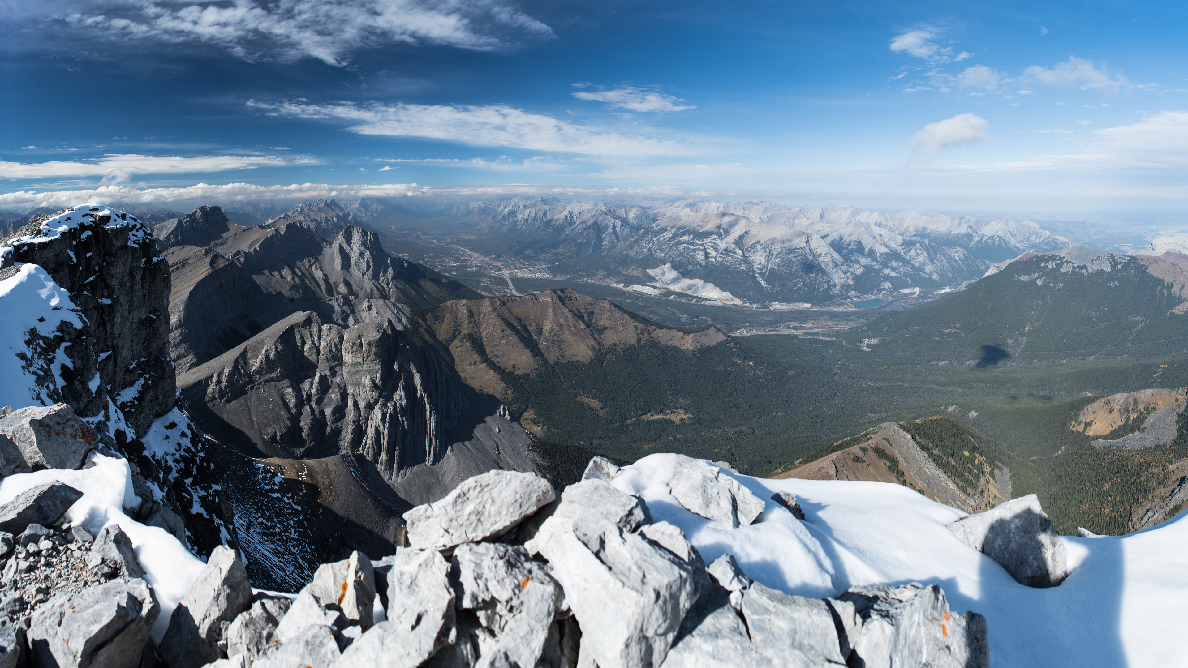
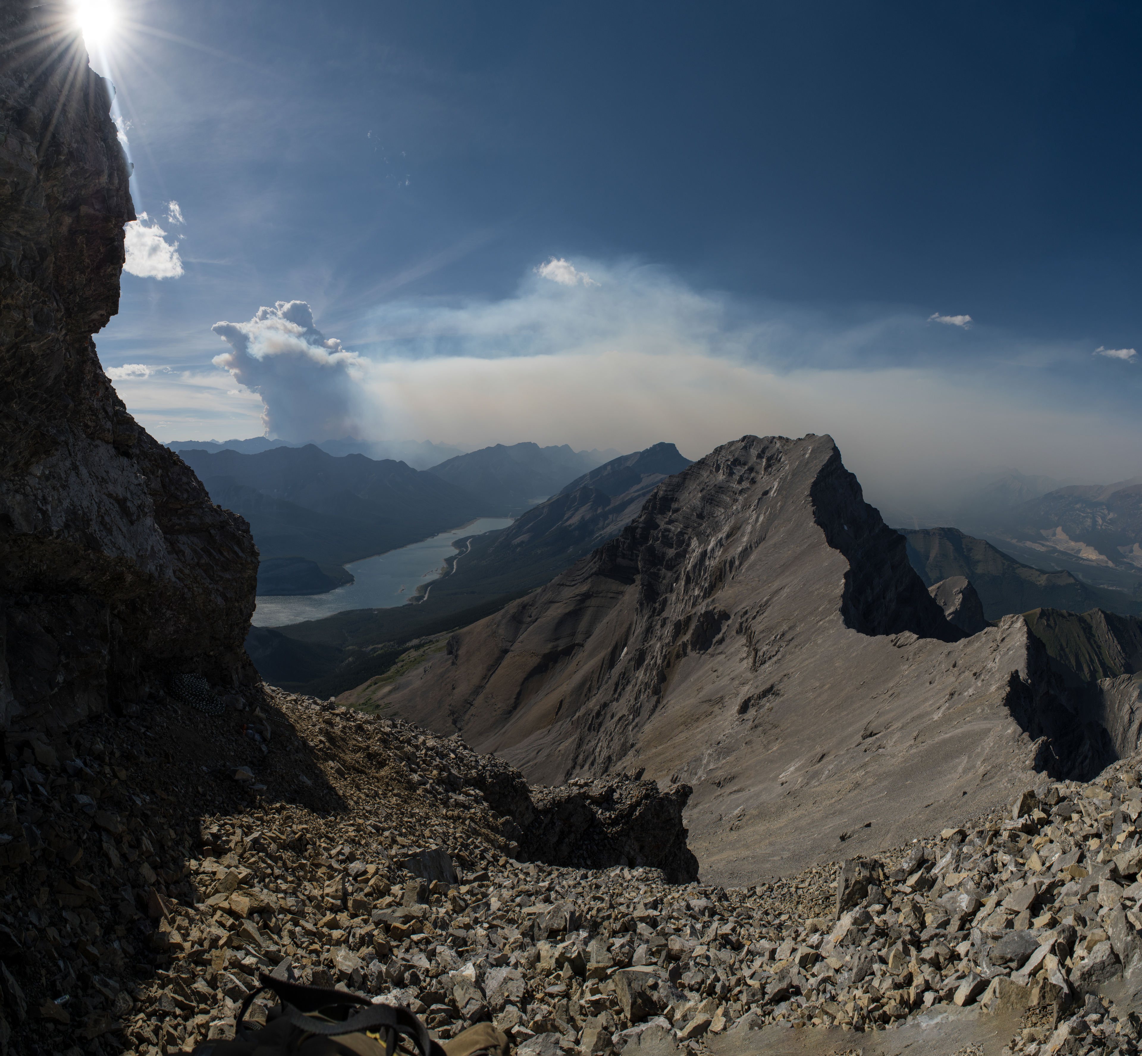
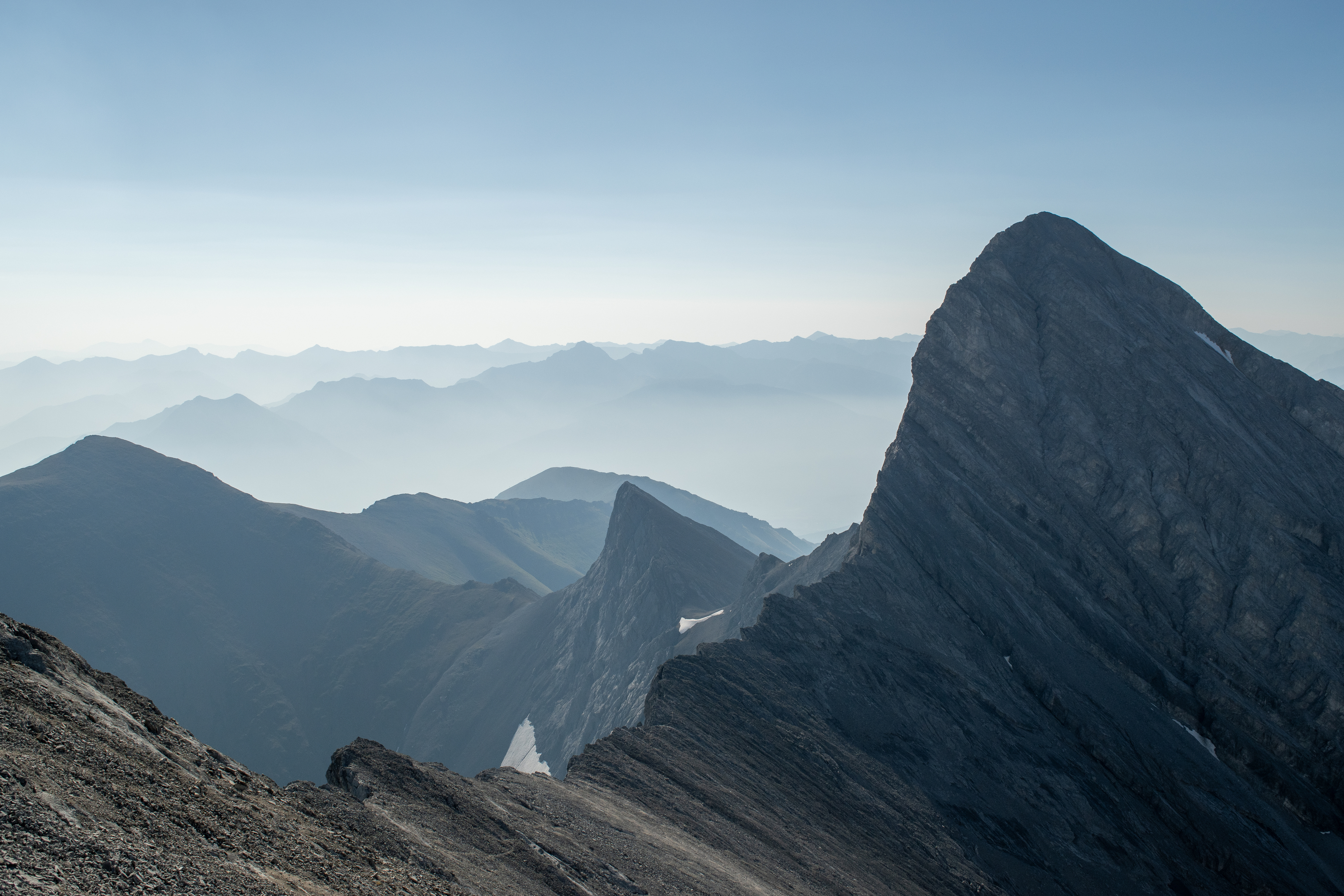
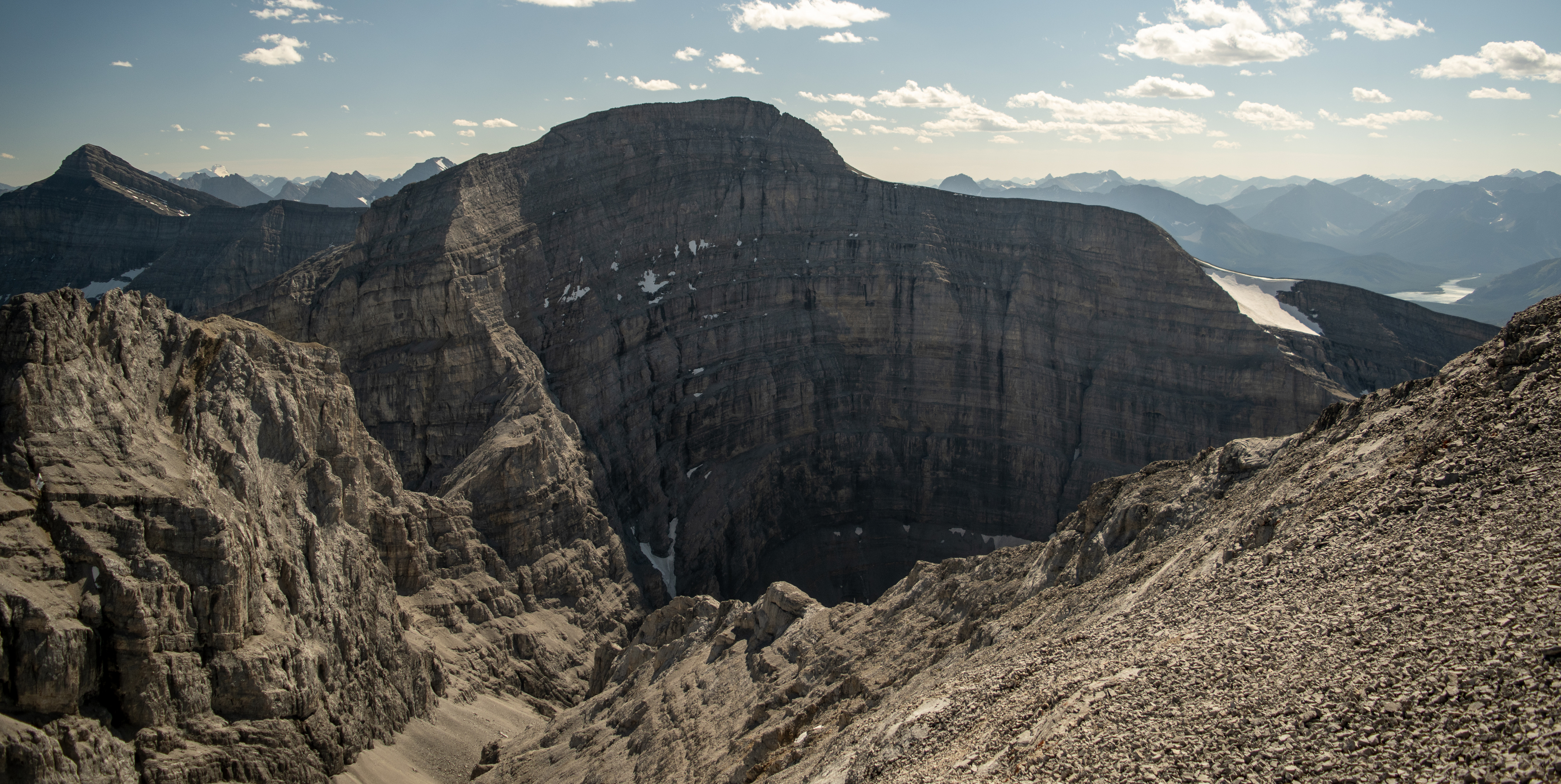
Above: summit snap (August 2021) from Tower Two looking at Tower One (right) and the Spray Reservoir
(2016 thru 2023)
Above: summit snap (August 2021) from Tower Two looking at Tower One (right) and the Spray Reservoir
I’ve been scrambling these three peaks as a traverse since 2016. I haven’t yet included the fourth and tallest peak of this massif in the traverse.1 The name has a history (and some political drama).2 My take, in a nutshell: French botanist Bourgeau, while happily picking plants nearby (😊), liked the windy scene with the big peak & swirling clouds and called it “Wind Mountain” in 1858. The Lougheed family had it renamed after themselves in 1928. While grandson Peter (Lougheed) was Alberta's premier, the name went back to Bourgeau’s “Wind” in 1983. The federal gov't (under P. Trudeau) didn't adopt it until 1985 (under Mulroney. I did say there was political drama). The three peaks to the north kept the Lougheed name.
It has earned something of a rep, it's true.
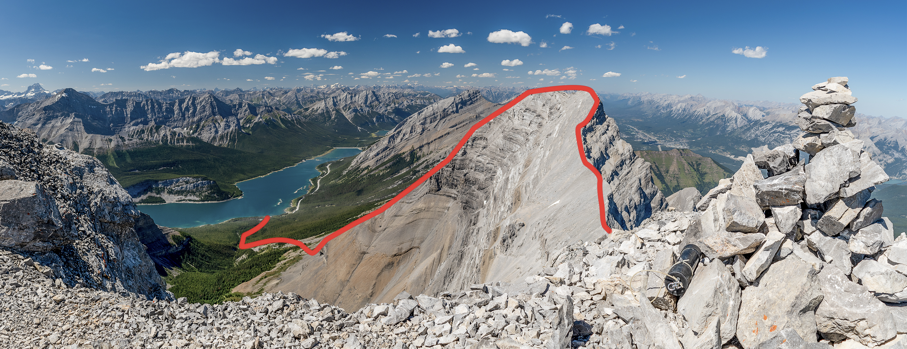
There are a few trickier, moderately exposed sections on the first tower. Where folks typically run into trouble (the kind where Kananaskis Safety sends a helicopter & crew in to long-line you off a ledge) is on the second tower, Mount Lougheed proper, just a few dozen meters below where I was standing when I snapped these two summit shots.
So I decided to start this TR there, with shots of, from on top of and around this section together with a few notes & suggestions.
It's a personal favourite of mine and if this traverse stops you at its crux or anywhere else along the way it still shouldn't be anything less than a fantastic day out. It certainly shouldn't end up with you being stuck.
Here’s the view from the opposite tower (Tower One).
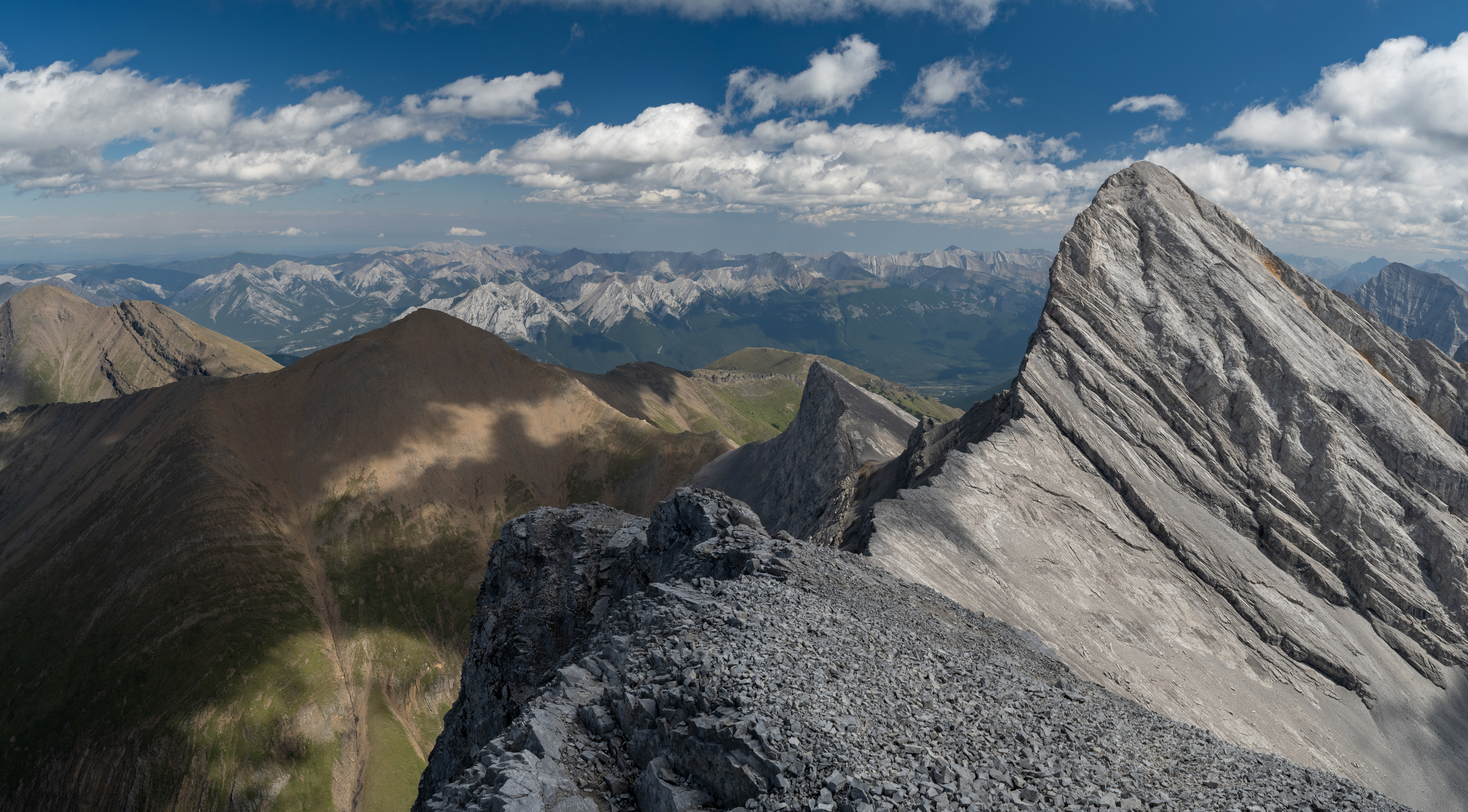
If it looks like it gets messy from about where I broke up the red line, it does. There’s some tricksy route finding in there. This traverse’s crux (excluding the fourth peak, Wind mountain) earns its rating at the steep section just before Tower Two’s summit.
I’d put the second tower’s crux — and that of the the three-tower traverse — at 5.3.
I Googled down a YDS 5.5 for this traverse. Digging through the references turned up a couple of TRs from summitpost.org (virus watch). One from a William Marler, but when I dig through the post it doesn’t look to me like he actually climbed it. Dow Williams has the other TR2 and gives the four (not three) peak traverse a YDS 5.5 in his post. He cites Dougherty’s “Selected Alpine Climbs in the Canadian Rockies” for the 5.5, yet I put more stock in the 5.5 for Wind’s north ridge for the fact that Dow mentions it, regardless of any source he cites. He makes it clear that the fourth tower (Wind Mountain) is the crux and he’s clear that Wind mountain’s north ridge is more difficult.
Which makes more sense to me.
If I think of stuff I’ve climbed where ratings make sense in relation to each other, 5.5 is too much for what’s here. Example: if tough sections around Mount Alberta’s crossover pitch or Yamnuska’s Grillmair are rated 5.6, which I think is fair, then I think 5.3 is a better fit for Lougheed’s second tower. I’ve moved out onto the northeast face through the crux. The exposure is brutal but only for a few meters, the rock is good (when dry) and it’s easy climbing (but still fifth class). I’ve climbed more technically demanding sections but the exposure wasn’t nearly as bad — maybe ten meters or so. At no point was I forced to do them both at the same time. And there were no long sections of technically demanding, sustained exposure, like what I’ve seen on Mount Alberta (5.5/5.6), Deltaform (5.5) or The Matterhorn’s Hornli ridge (5.4).
I think 5.3 is a good fit for what's here.
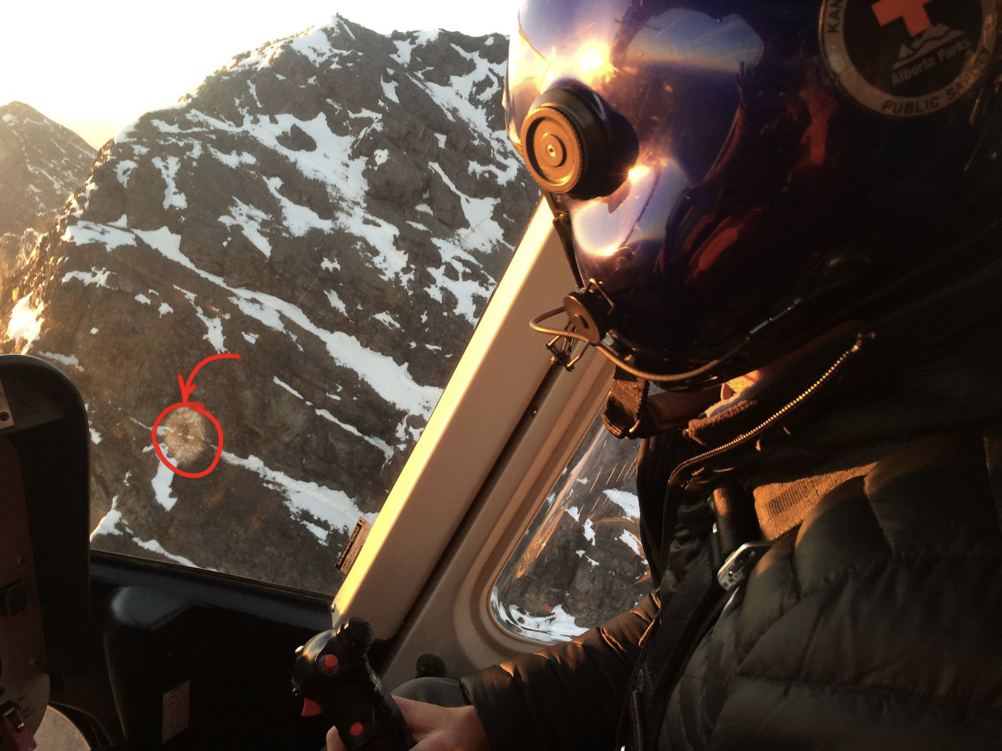
photo cred: Kananaskis Country Public Safety Section, Alberta Parks (2016)
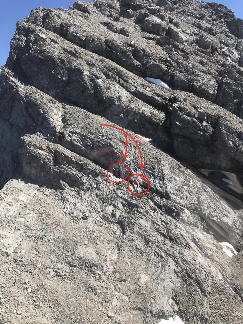
photo cred: Kananaskis Country Public Safety Section, Alberta Parks (2021)

Kananaskis Parks Public Safety snapped the last two shots from their helicopter during actual rescues from the same location: the north ridge of Mount Lougheed's second tower. The shots are five years apart but I recognized the location and the posts stood out. It wouldn't surprise me if a little digging turned up more.
For me, a big part of this sport’s appeal is about pushing the envelope. I like doing stuff I can get better at. Simple. I’m on all kinds of stuff now that I couldn’t touch before. Real progress is a big dopamine hit for me and likely is for the folks in these shots as well. Maybe for you too!
But here’s the thing.
We don't get stuck because what’s ahead of us is out of our reach. We get stuck because we can’t back out.
This traverse’s crux (for the first three peaks) is right here. It notches up to its 5.3 over a gain of only about 50 meters or so. The sasquatch-looking guy two shots up can’t have more than a dozen meters before he’s back in third class terrain. Then it’s just a few more meters’ stroll to the summit. But he can’t back out. So he’s stuck. The folks in shot 1 can’t back out either. They’re stuck.
If 5.3 is too much for you, this traverse will stop you right here.
Which shouldn’t mean you’re stuck.
So here’s a trick that helps me out. When I think I’m close to my limit, I downclimb and back out of moves I find tough. And I look for more than one option. It’s habit now, and has extended the reach of what I can comfortably scramble and downclimb to include much more terrain where I would otherwise need to rope up.
Try it that way and worst case, it’s an out-and-back of the two towers instead of a three (or four) peak traverse. Do it that way and by the time you reach where these folks are, chances are good you’ll have picked up the chops you need to see yourself through to the summit. If not, at least you’re not stuck. Either way it's still a great day out! 😊
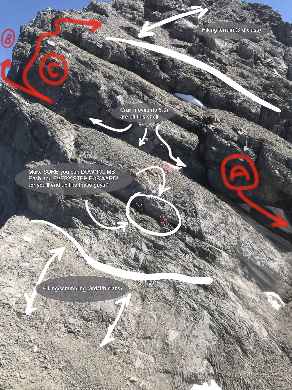
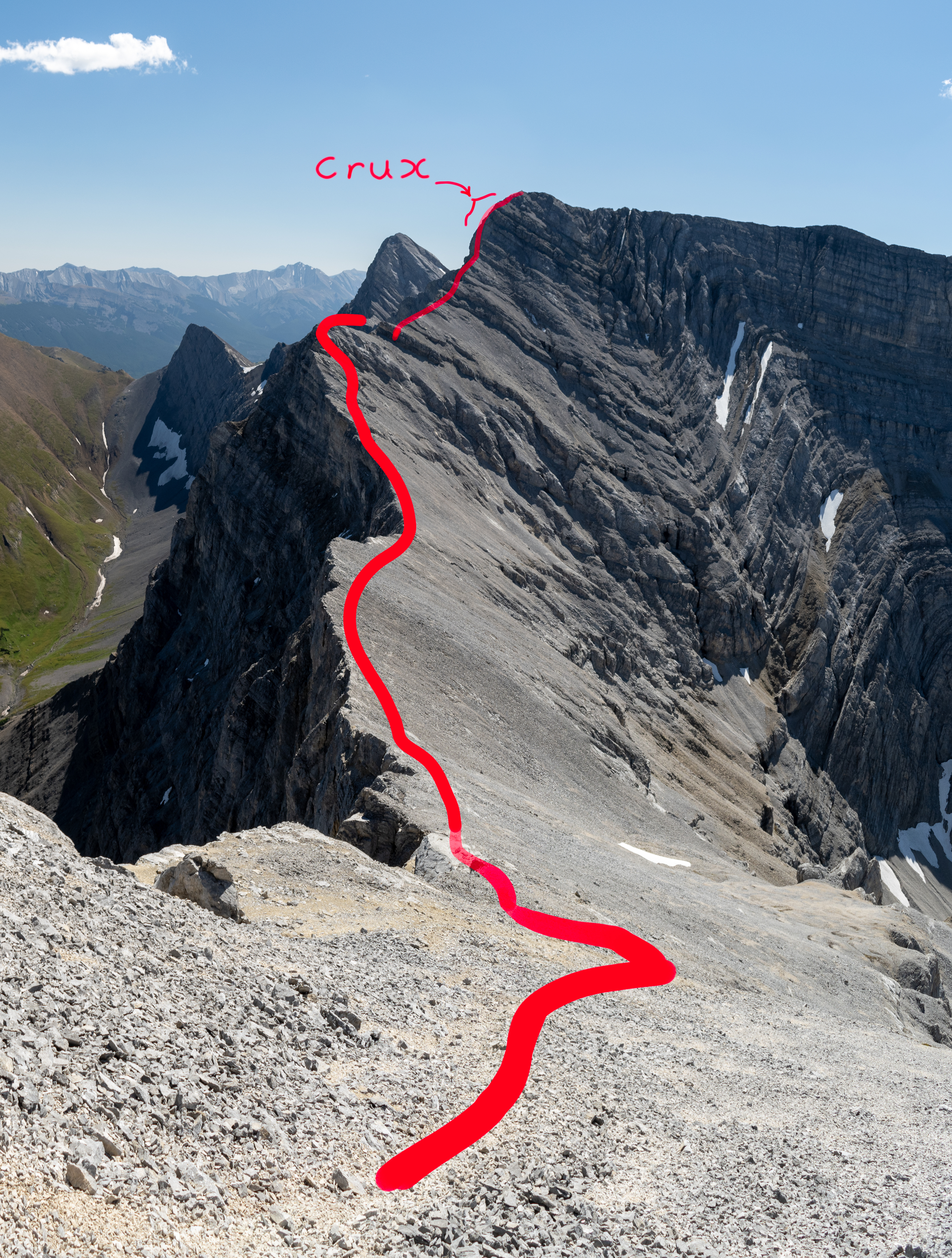
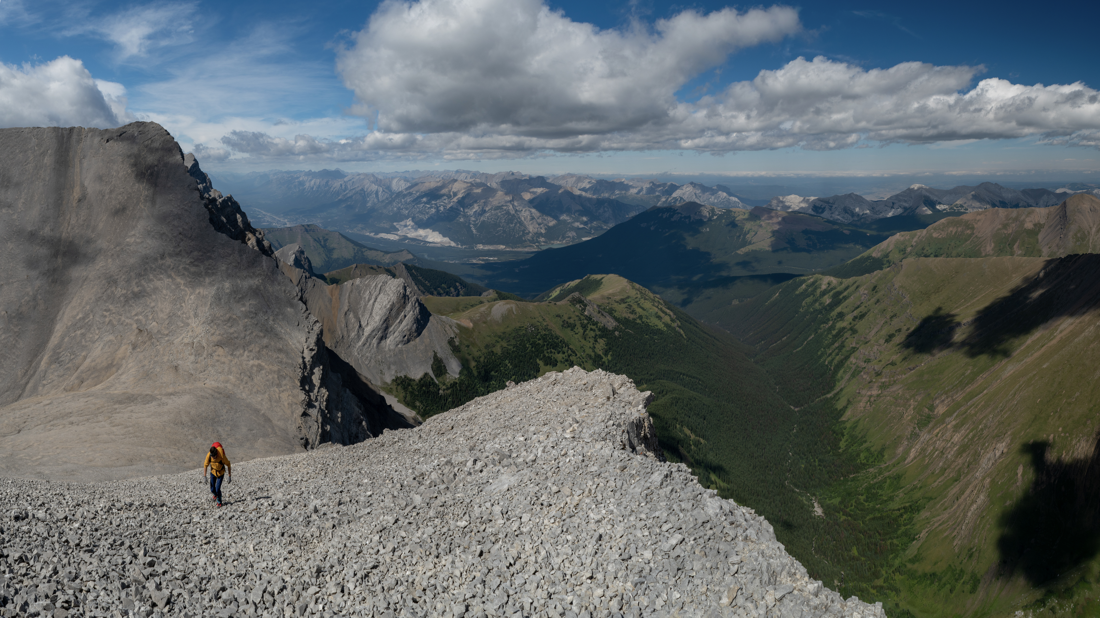
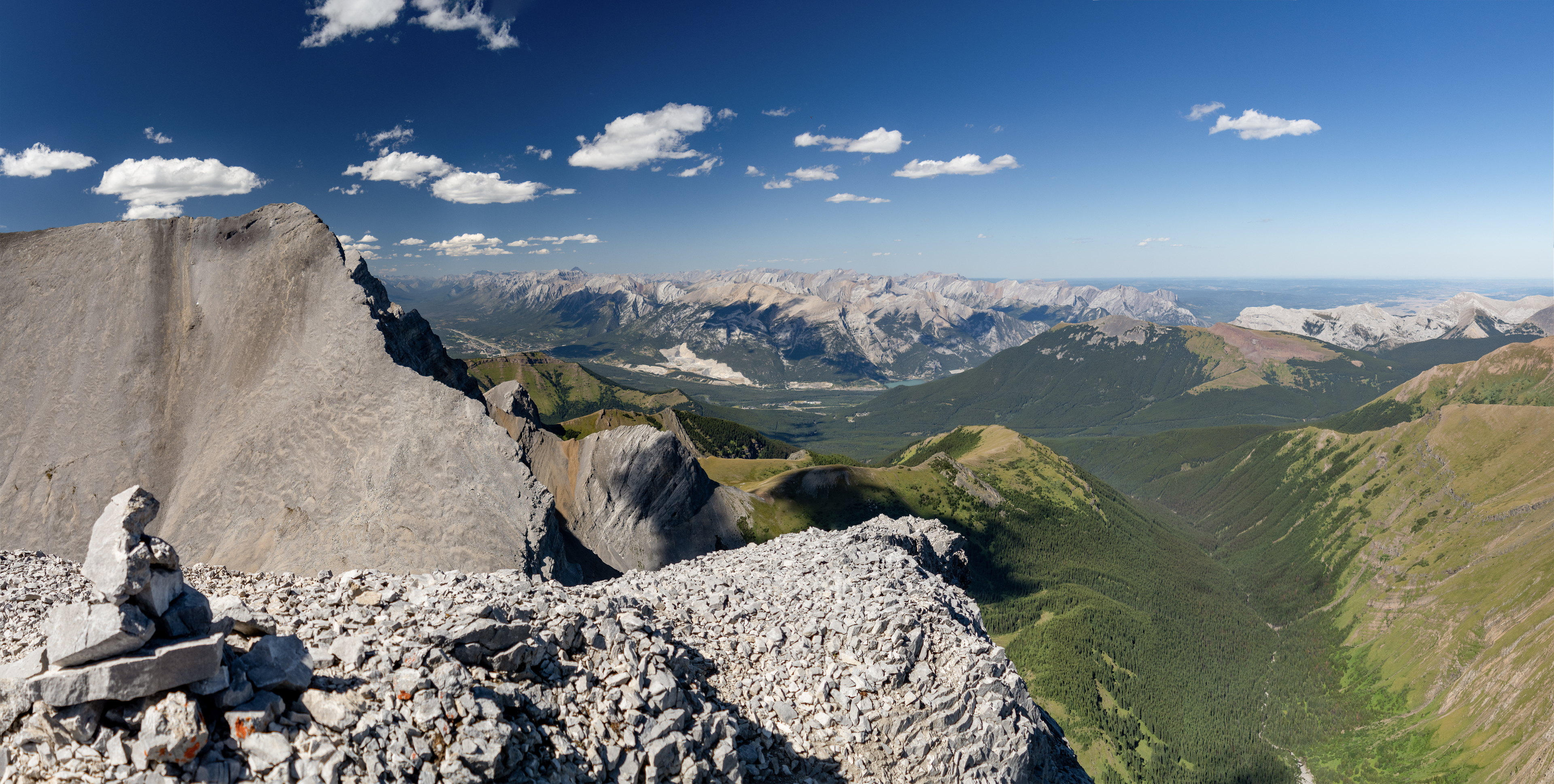
Here's that Kananaskis Parks Safety shot again. It’s the traverse’s crux from their helicopter, right in front of the crux itself, complete with stranded climbers. It doesn’t get any better than that! I’ve drawn in the routes friends & I have ascended through here. Perhaps this beta can be of use if you plan to tackle this traverse.
First off, these folks are so close! They’ve only got about 25 vertical meters until they’re back into hiking terrain. I've found two sets of options from the shelf just above them. One is a drainage just out of the frame to the right of the shot (my first few ascents in 2016 and 17 were through here), the other includes the chimney (“C”) further along the same ledge to the left, and options a dozen meters or so after wrapping around to the east face (“B”). These east face options are easier to climb, though the shelf itself is much more narrow and exposed than the north face routes. The chimney and east face ("C" and "B") have been my usual choice since 2018.
As for gaining the shelf above the stranded climbers, there hasn't been anything salient enough about it for me to remember since I first ascended this ridge in 2016, other than it being just out of the frame on the right of this shot ("A"). I wouldn’t rate any of the moves off the shelf above the stranded climbers more than 5.3.
I’d originally posted this shot and notes on a public Facebook face page after my 2021 trip through there and at the time, the page’s admin mentioned a fourth class option.
I haven’t been able to find anything less than the 5.3 up there, not to say there isn't one! I haven’t really been looking since camping trips up there in 2017 and 18. I’ve been ascending the chimney (“C”) and east face options (“B”) since then.
Find Elizabeth Imhof's 2021 TR here. I know she's been through there at least once since then.
One more thing:
Make sure the route is dry!
The options through this crux vanish rapidly with any snow or moisture whatsoever. A slip climbing the drainage out of the frame of this shot to the right ("A") would likely stop at the scree shelf, though it might not. If it did you could still really hurt yourself. The rock in this drainage is plastered with lichen and any moisture or lingering snow, anything draining from the face above turns this otherwise manageably pleasant route into a sloppy, frictionless mess. The chimney and options around the east face move out of reach with any moisture for much the same reason. So if you’re approaching this traverse from Highway 1, have a good look as you drive by and make sure it’s clear of snow. Otherwise it's more of a mixed climb than a scramble, and wants the appropriate gear.
Happy scrambling!
let's head back to the approach...
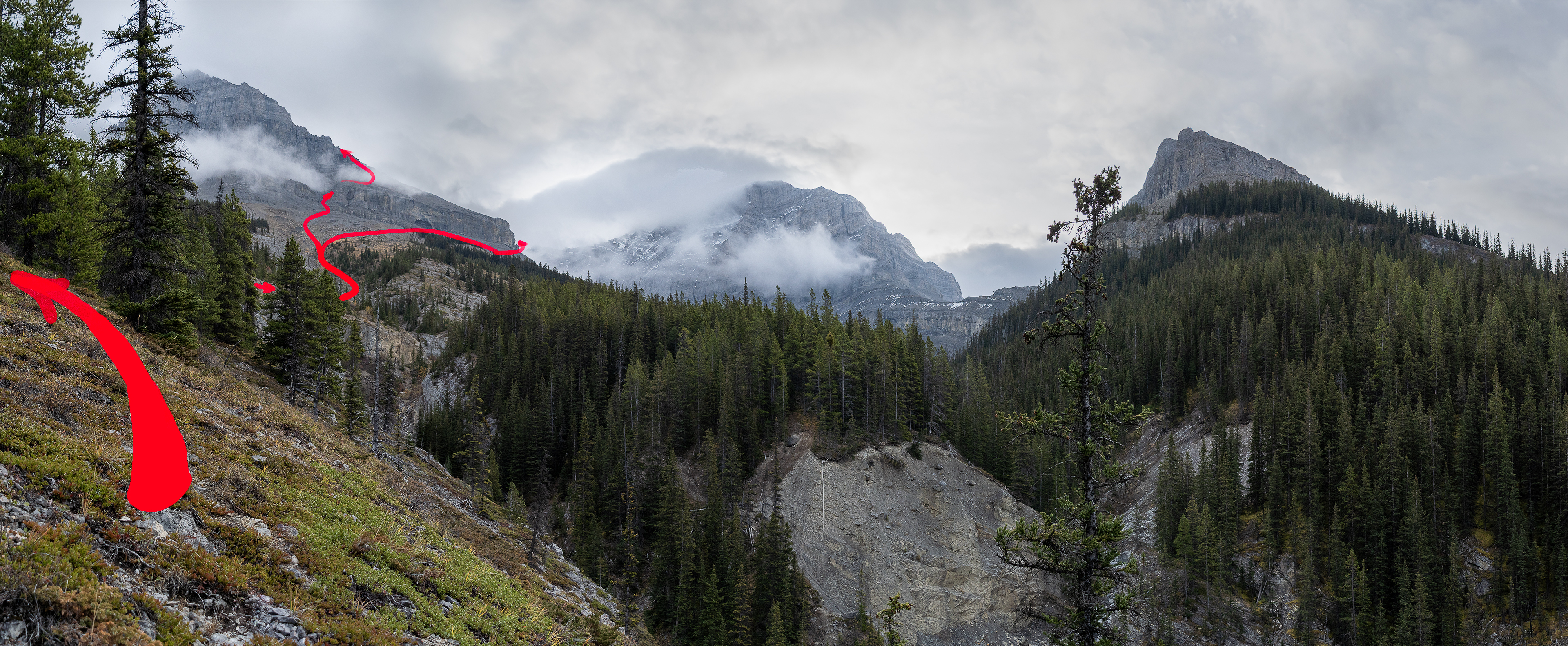
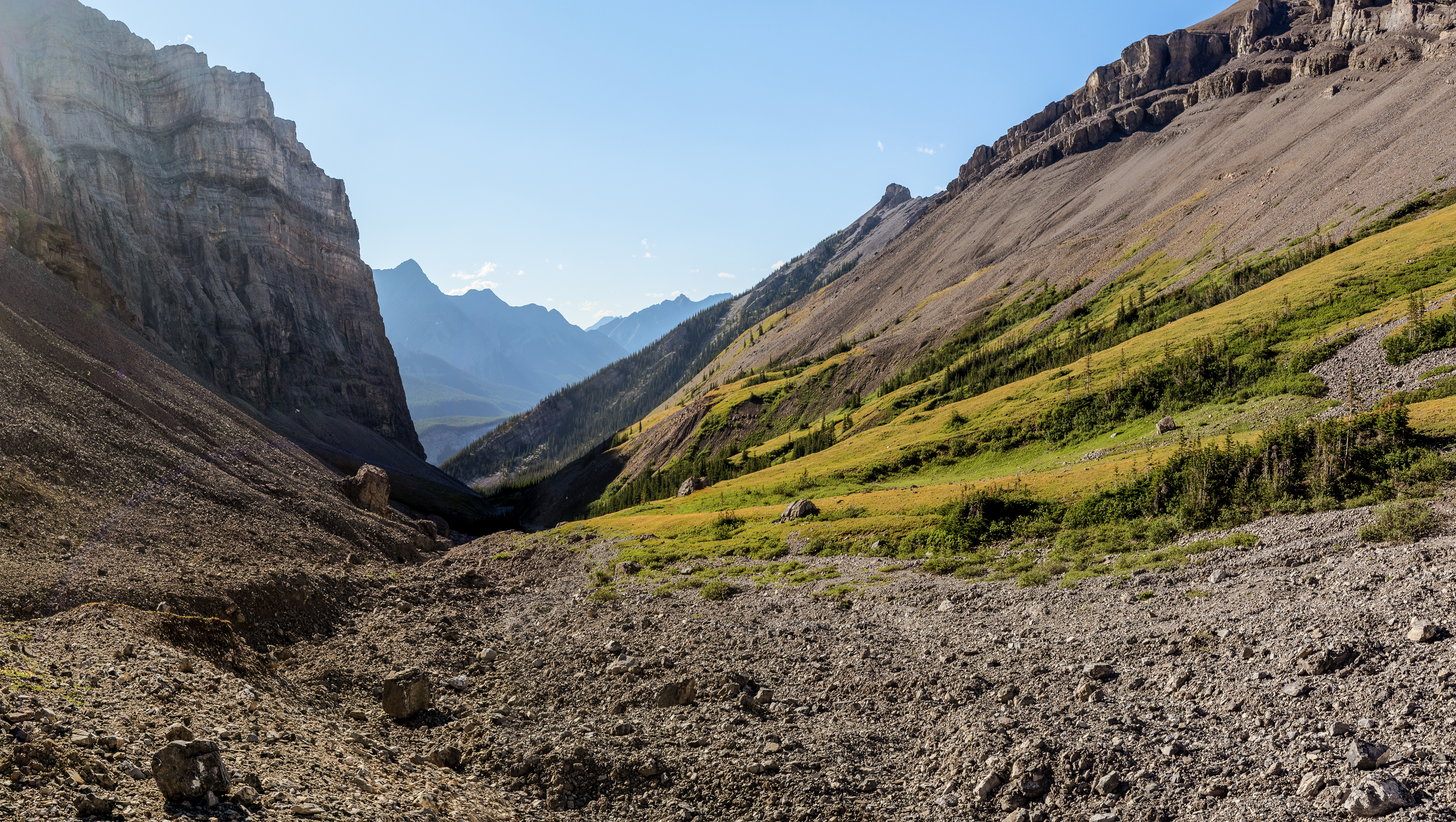
After more than enough boulder hopping, stump stomping and bushwhacking I land here, gaining the ridge from the (climber's) left side of the drainage. The trail is spotty, though the bushwhacking is tolerable, reasonably short-lived, and the views open up even before we hit the tree line.
I stay left, keeping the cliff bands to my right, gain and scramble up the draw to the break just left of the prominent nose and start of Tower One’s south ridge. I gain the south ridge from any of an assortment of fourth- to fifth class routes along the wall in that break, depending on what I feel like climbing. I’ve hiked around that nose to gain the ridge back there but the scrambling isn’t as much fun.
I've also gained the south ridge clambouring up the drainage below and right in this shot.
And it sucks.
It's pretty much what you'd expect from this shot. Better to keep left, stay high and put up with a little bushwhacking now. Otherwise it's more later. Worse. Annoying.
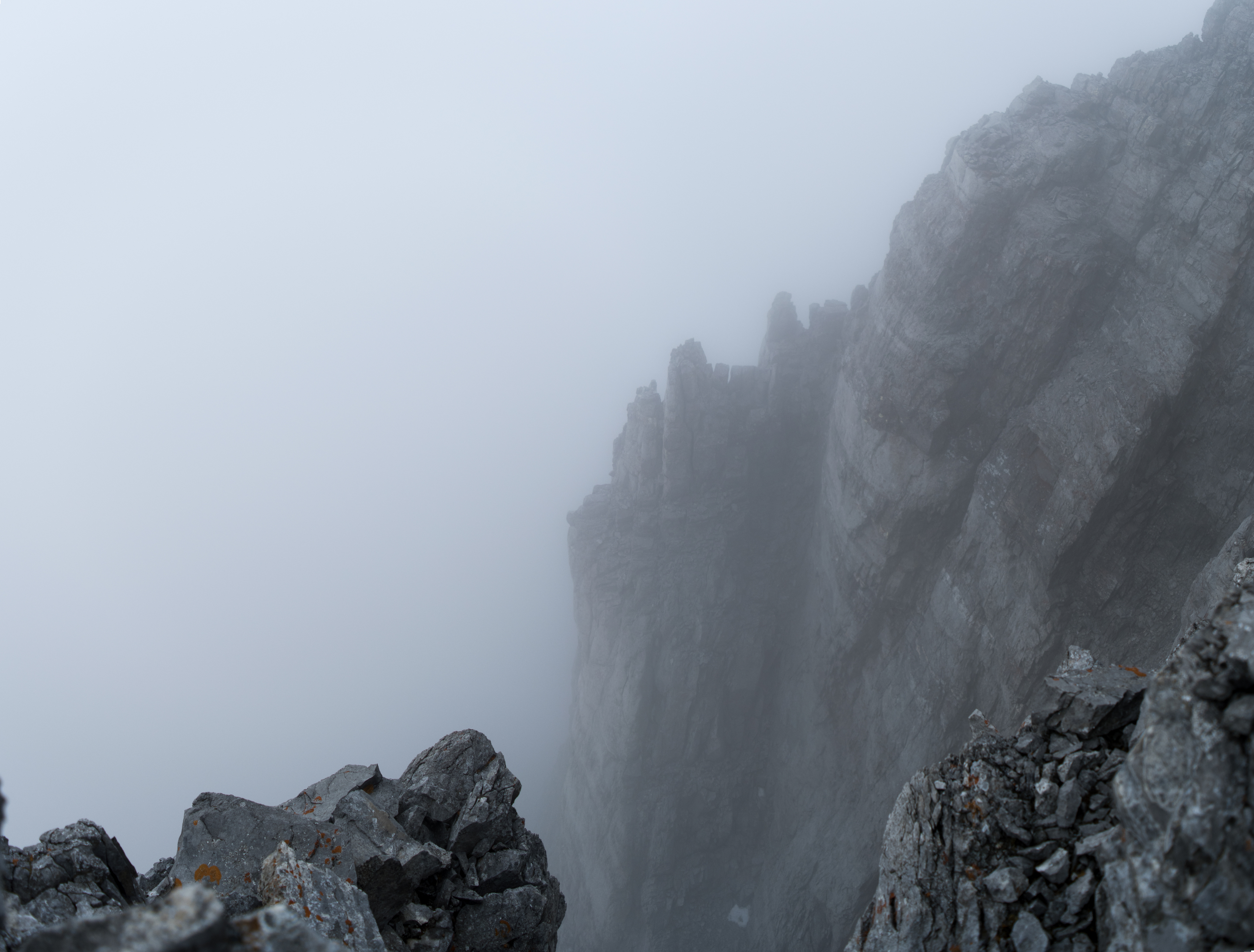
Above: Maybe Golem's down there? Couple of hobbits?
I actually was alone when I snapped the spooky scene just above. And I wasn't going in circles. Yet the scene does remind me of another set of towers out of a Tolkein tale of some reknown.
Here it is again (below) on a bluebird day.
I'm near the top of the first tower's south ridge, on top of its crux by this route (I'd put it at 5.2). The northwest ridge (and its spicier route, haven't done it yet) is on the right. The popular and well-worn Windtower and Rimwall trails wind their way up to their summits just below, on either side of the pass (West Wind Pass).
The Three Sisters are in there. Assiniboine pokes its head above the crowd, as it does from just about anywhere in Canada's Southern Rockies once you're on top of 2800m or so. It's on the left edge of the frame. Temple, the Stanley glacier and a pile of other notables are all in the shot. They're tough to distinguish at the posted resolution, but easy to see from up here.
If it's tough here, there's a long stretch of respite for you, all the way up to and past Tower One's summit and along its connecting ridge with Tower Two until the col with Tower Two. Then it's over.
It gets worse. Or better (more fun!), depending on how you look at it. By a full climbing grade.
If you're like me and you’re near your limit, you're somewhere between a little spooked and terrified. A good thing. If you're forced back this way, if you or someone else is tired or injured, if you have problems with your group (been there) or it's a bad date (been there too), you'll feel better if you've already worked through the moves and recognize the terrain.
A GPS, even with your own track, won't help much help here.
When I’m in or near this “type 2 fun” zone, I downclimb and rework the moves until I’m comfortable and I push to find and work at least one other option before I proceed. I’ll build a funny looking cairn (some folks now frown, I’ll come back to that) or add a few stones to one that’s there. I'm building contact- and muscle memory and strengthening my association with this terrain, adding depth and facility to recognizing it on my return. I turn around and look for cartoon characters in the rock patterns I'll recognize my way back down (a habit I picked up in the pre-GPS days. I like the Looney Tunes), even if I doubt I’ll return the same way.
Whatever it takes to help myself recognize where I am and how I moved on my way back down. Because the rock I climb is completely different than the rock I downclimb, even if it’s exactly the same rock. On exactly the same route. If you don’t get that, you’re risking real problems on this very traverse.
...so why should I worry about this 5.3 traverse?
Since 2017, I’m on top of Assiniboine most years at least once or twice each year by the north ridge or different routes up the south face. I was up top three times in 2023, including twice in one day (from the RC hut). It would have been four that year but friends & I were turned back — also by verglas, also on a north ridge. ("also"?). If I’m forced to pick a favourite peak, that would be it. To the point where I’m annoyed when people refer to Assiniboine as the “Matterhorn of the Rockies”. I've summited both and they’re different experiences.
Why not call the Matterhorn “The Assiniboine of the Alps”?
I grew up scrambling Canada’s Southern Rockies. You don’t see Assiniboine until you’re close to 3 km elevation, then it grows to dominate the skyline. From anywhere in our Southern Rockies. I’ve been obsessed with that rock since childhood.
That said, throwing a 5.5 at Assiniboine's north ridge is quite a stretch. It's fifth class, but barely. And only for a couple of exposed moves and touchy route finding near the top. There's an abundance of more difficult and exposed fifth class available, but from a path of least resistance perspective, I think 5.5 is out at least three grades (I'd put it at 5.2).
Route grading happens a little differently here than what I've seen across the pond and some grades are a little wonky here. Accusing Assiniboine's north ridge of a 5.5 is a case in point. I'll save that rant for another TR. Maybe Assiniboine's, if I get to it.
Though I haven't yet needed a rope up here, I still wouldn't be comfortable on this traverse without one in my pack.
It isn't just for me. I recall a trip up Mount Northover years ago where I'd reached the summit ahead of someone climbing behind me. I wasn't thinking anything "rope". Then she was struggling and I wished I'd packed one. It turned out OK, she turned around and I stood and watched until she was off the ridge.
But it was uncomfortably close to not OK.
A late afternoon, late-September snap roughly midway up the first tower's south ridge. The snow was a nice aesthetic touch, though it complicated movement on the steeper ledges throughout the route and in one section in particular.
(Guess where?)
The day started out overcast, then cleared by the time we reached the second tower. It worked out well.
Carson pauses on our way up Tower One's south ridge to take in the scene
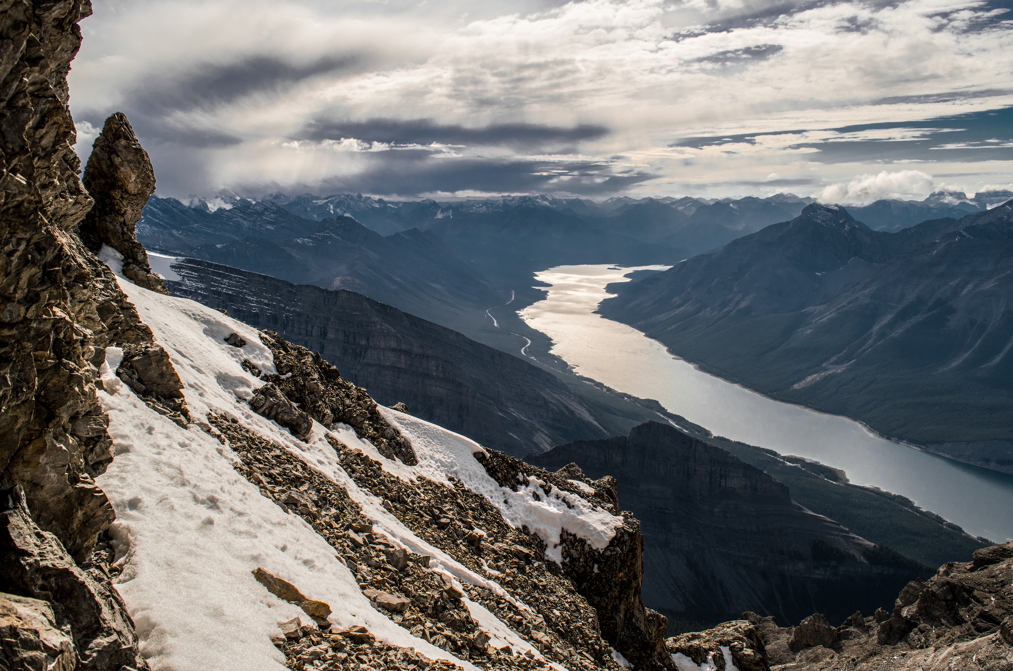
Still on Tower One's south ridge, not far from the last shot's position (but a few years earlier). It was hot! The wildfires were raging away in BC, though you wouldn't know it from this shot (those are coming up!). I packed food, overnight gear & camped one night on the connecting ridge near the col and a second night on the far west end (your right in this shot) of Tower Two.
The next four shots are from the same late September trip. Temperatures were on either side of freezing. Even with the lingering snow, the day's heat melted enough snow and ice back to expose enough rock to keep the ledges and holds grippy.
The second of four late-September snaps.
It's not a lot of snow, though it's more than it looks from here. And it's north facing. On the warm side of the freezing point the holds and placements are wet but manageable. On the other side of that point they freeze. It happens all at once over large areas of the same face.
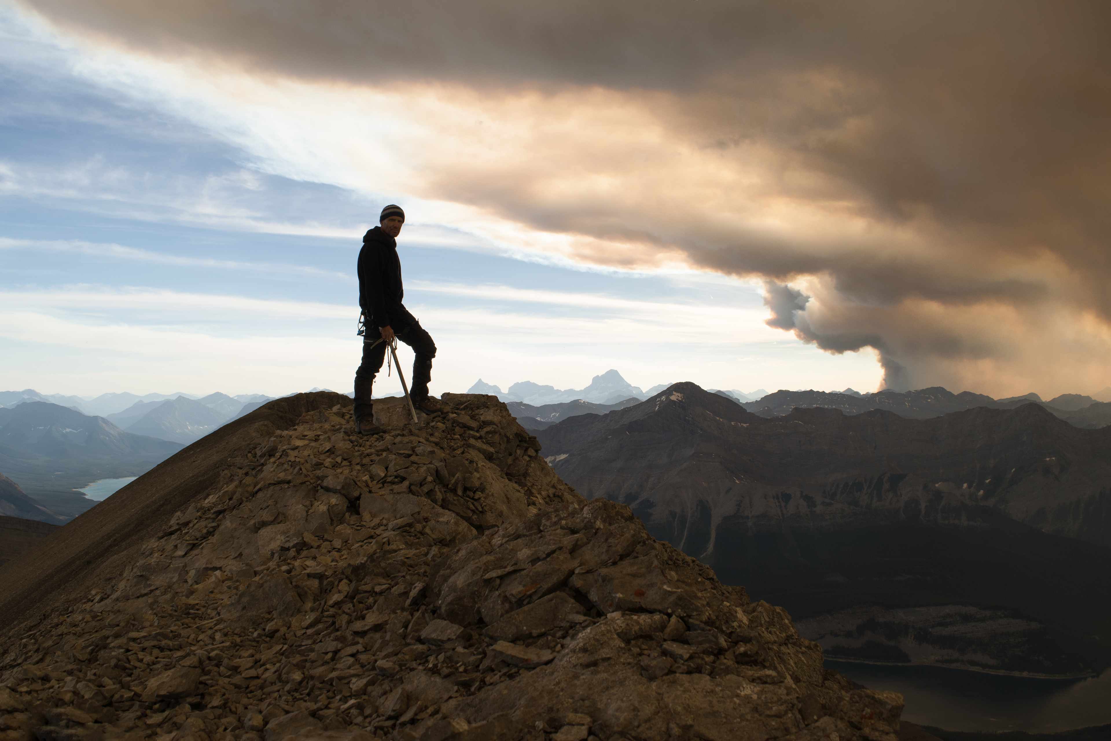
For me, it was about 6 pm, most of the way up that face – same location, same face as the two shots from Kananaskis Parks safety.
I was in the middle of a move. I'd barely stepped off a placement to repostion, then couldn't step back onto the same placement. In those few moments, the damp had frozen into a thin film of solid, frictionless ice.
I was able to climb onto narrow, snow-covered shelf. I couldn't move off that shelf until late the next morning.
F***.
No tripod. No clue how to shoot astral photography (and it shows). I plunked the camera down in the snow and voila. Taurus is in there, with the Peiadis. Still, you get the idea. It was quite the show!
An odd contrast.
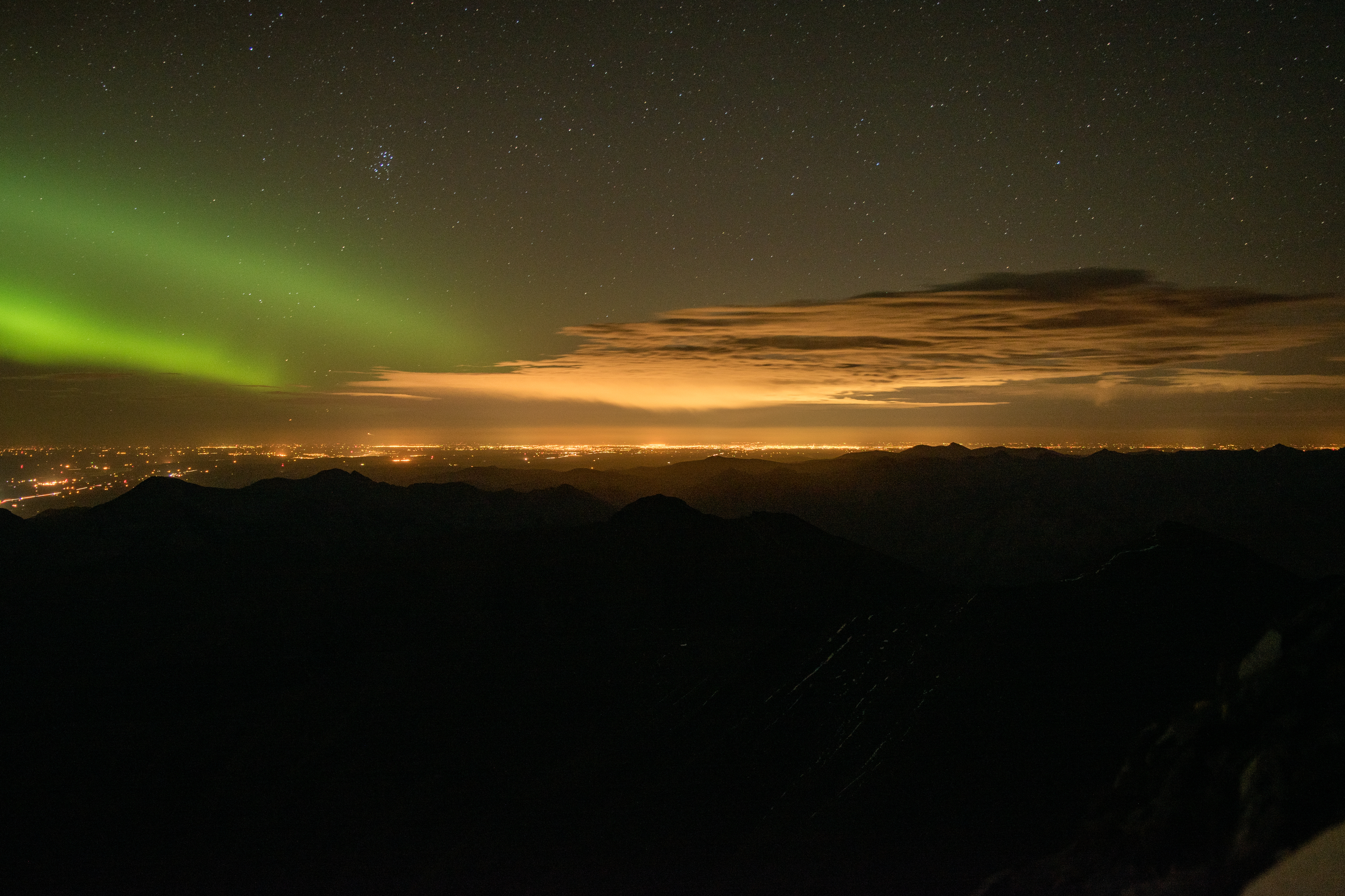
I was stuck on this cold, narrow ledge on Mount Lougheed’s near-vertical north ridge, barely 50 vertical meters below its summit. And it was cold.
Yet the skies were clear. Calgary was close enough to offer its warming tones to my chilly predicament, yet far enough for the dazzling starlight display one comes to expect out of the city on a clear, moonless night.
Then the light show started.
And what a show it was. It reminded me of a spectacular scene from Jackson's "Return of the King", the Hobbits' view from the stairs (of Cirith Ungol) when Sauron's armies cross the bridge from Minas Morgul. (In case you haven't guessed: big LOTR geek right here).
I’d never seen the northern lights display like they did that night. They lit up the entire northern sky.
And I had the front row seat.
Cool.
(in a good and bad way)
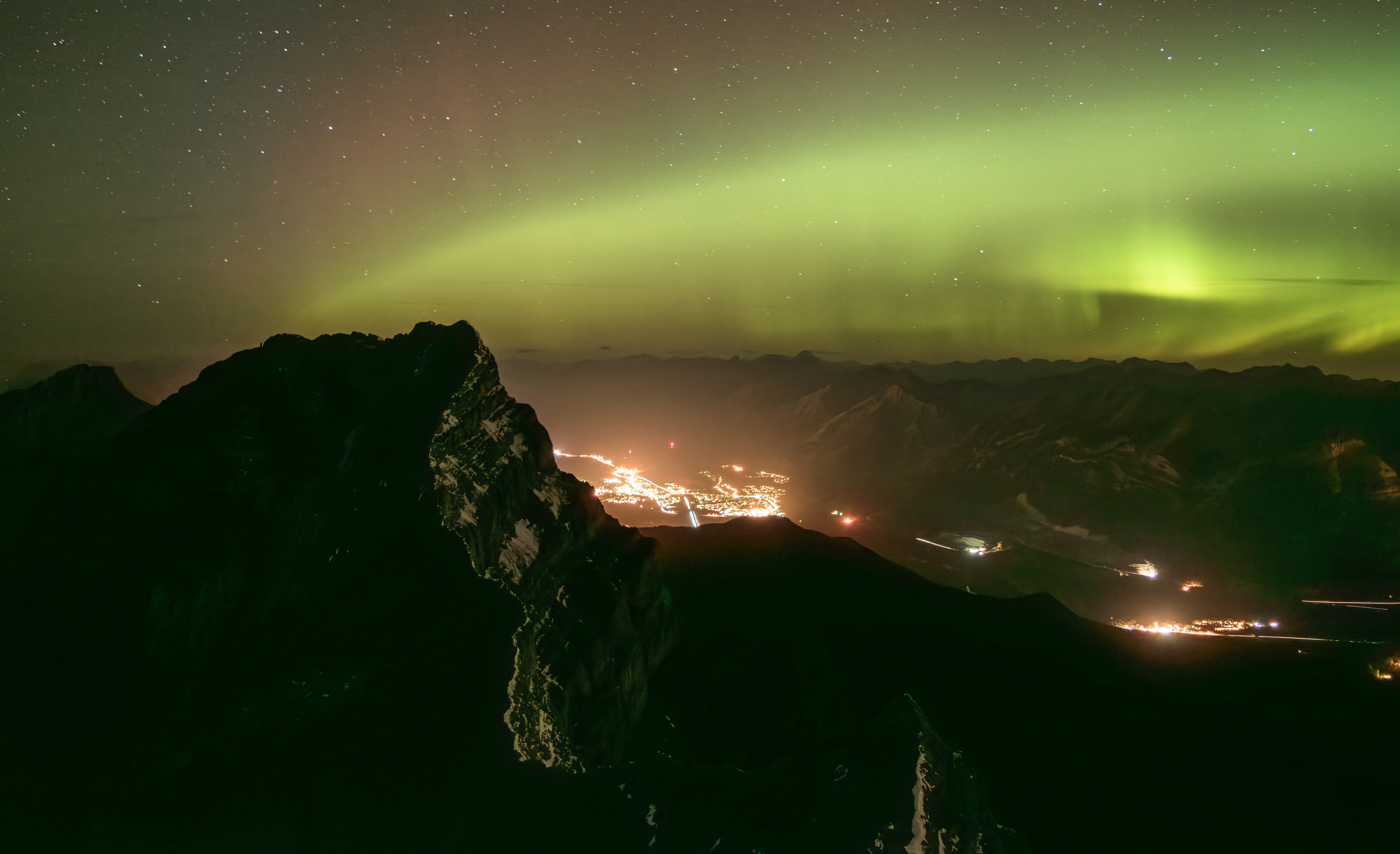
We lose the depth with the shot and I’ve only caught the lower band here. Their arc ran all the way past the horizon. Would it be hundreds of kilometers? Truly spectacular.
The light show was over about midnight. I didn't have anything to insulate against the rock and couldn't really strech out to doze.
Long night.
I'd brought enough extra layers to avoid hypothermia but not nearly enough to make for a pleasant overnight up here. As soon as the verglas flashed back to moisture the next morning I pulled the plug on the traverse. I didn't care how close I was to the summit. I was concerned the temperature would drop on my descent and I would be stuck again.
I'd just had a hard introduction to verglas. I knew what it was but had no idea that a whole face would flash into ice all at once, and in seconds. Of course it makes nothing but sense now: the film is just millimeters thick so it freezes fast but still just looks damp.
You don't know it's ice. You can't.
Until you try to move.
Now I was way up here on a mountain in precisely the right set of conditions for it to be full of the stuff.
I wanted off this rock.
I should mention one more thing about the lightshow. I'd thought the lights were the "Steve" variation and looked them up. Steve is silent, so I thought (and still think) they must be Northern Lights for their noise.
Yet it turns out there's some debate as to whether the Northern Lights make any noise.
Highway 1 was close enough to hear it, yet still around 15 km north of where I was and nearing 11 pm mid week. So fairly quiet. I know what a Highway sounds like when camping overnight near one. I do it all the time.
This was no nearby highway sound. There was a kind of crinkling, crackling sound that seemed to vary in relation to the intensity of the display.
Not sure what else it could have been.
Hmm. So I'm not sure what's up with that.
(...some bad Lembas bread?)
Fast forward ten months. Same ledge, a whole lot warmer and no snow.
I'd camped the night before just a little further down the ridge. I'd arrived early in the day, packed a copy of "Freedom of the Hills" and spent the afternoon practicing knots, setting up anchors and practicing rappels. It was a pile of fun, though my pack was heavy.
I spent much of the morning and early afternoon crawling ALL OVER this section, above and below this shelf, burying the route choices in my spine. I was MAD that I'd been checked here the year before (2016), even if the verglas wasn't an unreasonable excuse. Verglas goes fine with the right gear. But I wouldn't start climbing ice and mixed until 2020.
I found several routes, though I wouldn't put any of them at less than 5.3.
Except last year (2024), I've been up here at least once each year since I snapped this shot in 2017. Each time I return I'm able to climb options I couldn't the year before. It's one of the reasons I keep coming back: experiencing real progress is truly motivating. (As it is in any worthwhile endeavor. Is it not?)
So we're not quite done with the LOTR thing just yet. To the right of the strange column cloud, a larger reddish cloud covers the north end of the Spray Reservoir, Goat Pond and smothers the town of Canmore.
Those poor people. In the last section I'd been comparing the happy little mountain town to Minas Morgul. Now it would be like downtown Mordor down there.
I'd mentioned my earlier obsession with Mount Assiniboine, for how it rises to steal the skyline (and the show) as you gain elevation in the Southern Rockies. Well there it is, center frame. Only this time, Assiniboine is upstaged.
It's all Mount Doom in this shot.
Mount Doom being the Verdant Creek fire.
I think I have captures from another device but the column cloud in the last shot, snapped about two hours before this one, only took a few minutes to explode way up into the upper atmosphere, waaaaay above any other cloud.
It was like what I think a volcanic eruption would look like (if I ever see one).
I snapped the next shot from where I'm standing in this one after about an hour...
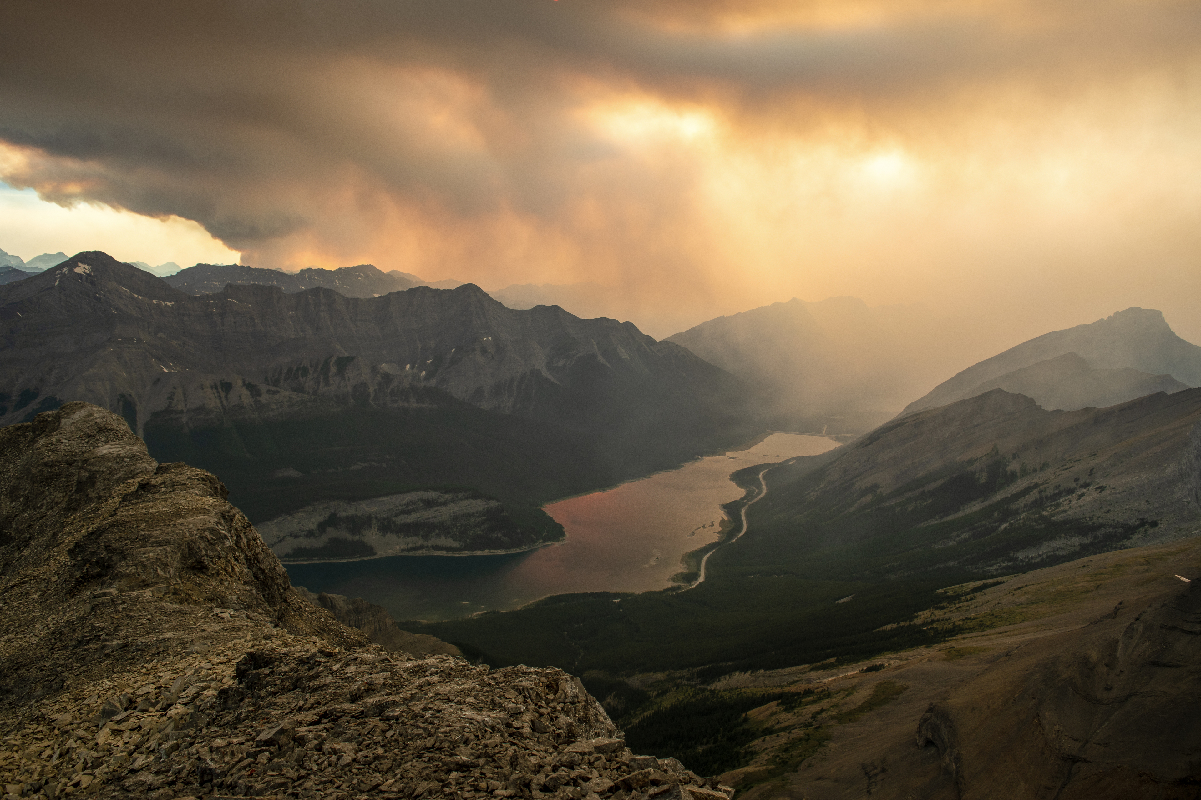
I would camp that night on a flat spot towards the end of the feature on the left in the shot above, overlooking the Spray Reservoir. Ordinarily, the view and scene would be sublime.
Not this night.
So I cooked a meal, brewed tea, crawled into my bag and went to sleep.
I woke once during the night and by then I could barely see ten meters with the headlamp. The light reflected off chunks of ash, hanging in the air with the stench of the nearby wildfires. If you were anywhere within hundreds of kilometers of the area at the time I don't have to tell you what it was like.
By sunrise the smoke had settled somewhat.
Sunrise was...
How do I put this.
Sunrise was... well...
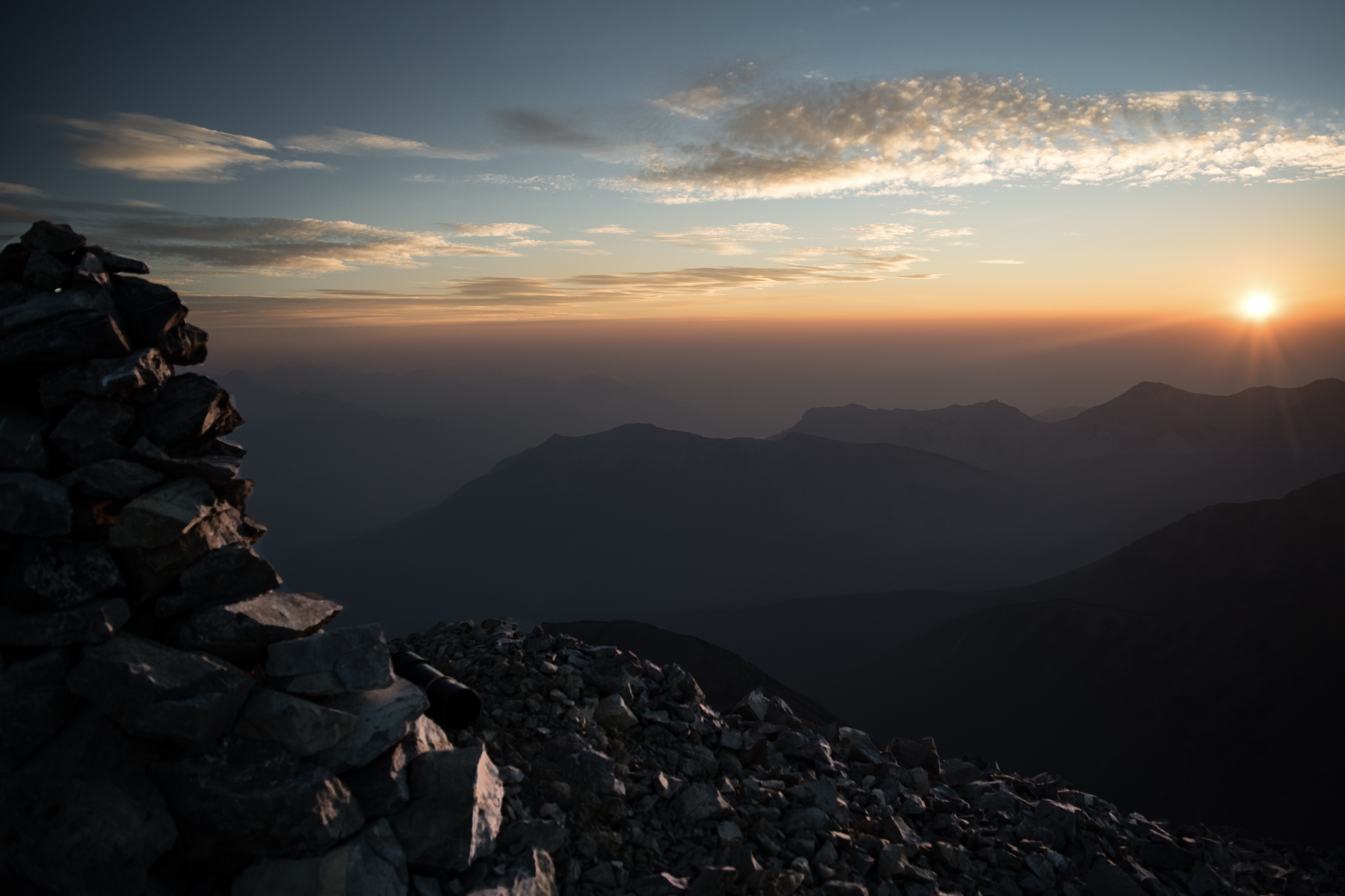
Sunrise from Mount Lougheed (Tower Two)
And stinky.
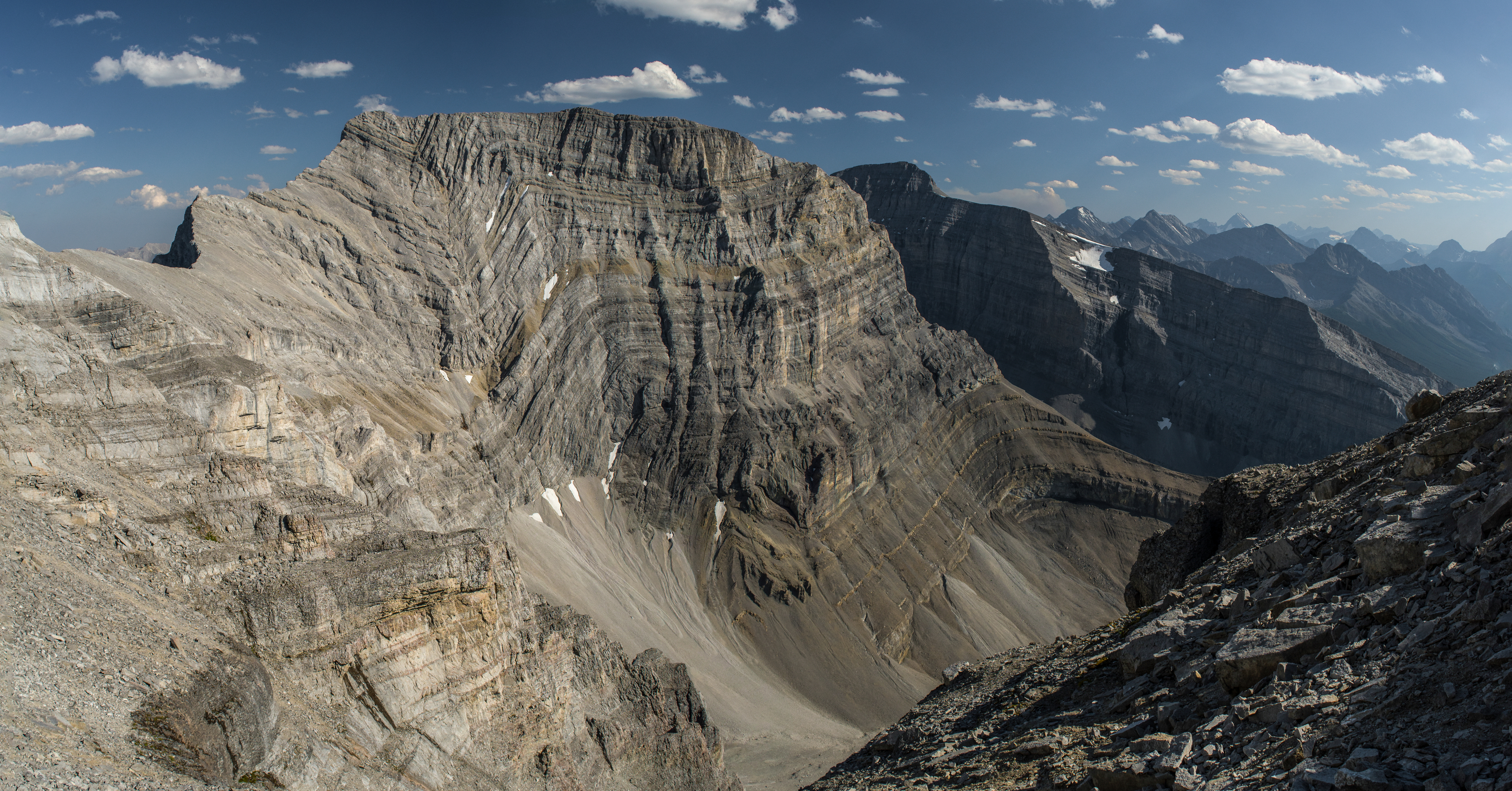
Wind Mountain, the tallest and most difficult peak of this massif, surrounded with smoke from nearby wildfire activity. I haven't yet included this peak with the traverse. That ridge looks tough!
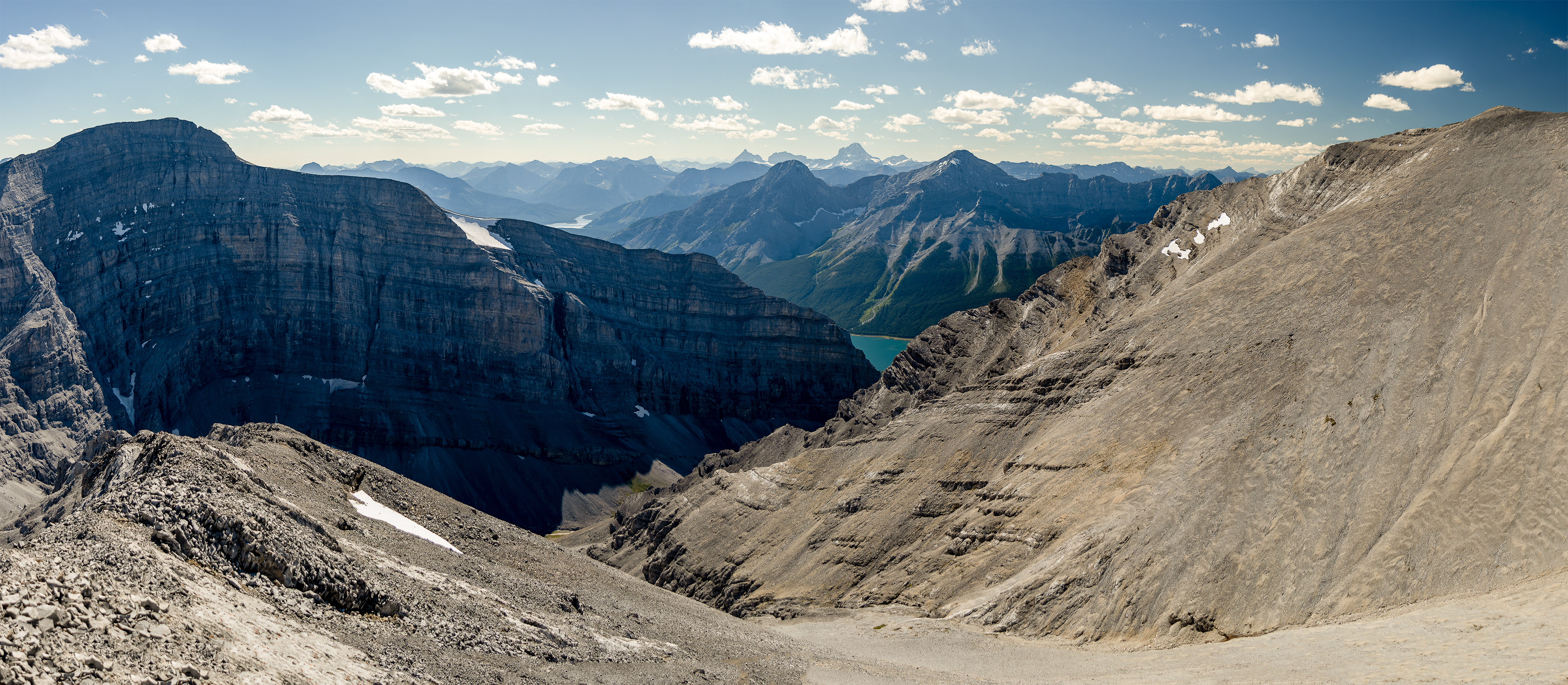
The smoke (and stench) would clear a little more by the time I reached the third tower's summit (easy third class descent from the second- and ascent of the third tower), the last of Mount Lougheed's three peaks. Wind Mountain shares the massif but not the Lougheed name.
The smoke had settled more. The visual effect wasn't entirely unpleasant, though the lingering stench was.
With this next shot — a smoke-filled snap of Wind Mountain from Mount Lougheed's third and final tower — we'll leave 2017's "Smokocalypse" back in 2017. I wanted you to see some shots of the Verdant Creek fire and its affect on this region from up here. A strange scene. Truly. But I think that's enough.
I have captures from better trips up here. Bluebird days. Moody days.
So let's move on.
Snapped from Tower Three's summit looking at Tower Two
Absolutely.
If I’m not camping or stuck on a frozen ledge up there, the traverse normally takes me between ten and eleven hours. There's a quick 2 km bike from where Spencer Creek meets the highway to another drainage where I park.
Once past Tower Two's crux, it's third class the rest of the way (if that's what you want). I've only ever descended by one variation or another along the drainage between this tower (Tower Three) and Wind Mountain (left), though apps like Gaia and AllTrails show the more popular Mount Lougheed hiking trail gains the second tower's summit (the second tower being Mount Lougheed) from its south ridge and face.
I haven't gone that way.
The third-class scree bash ascending the third tower, seen from its summit
Towers One and Two, Canmore and the Bow Valley from Tower Three, on a bluebird day!
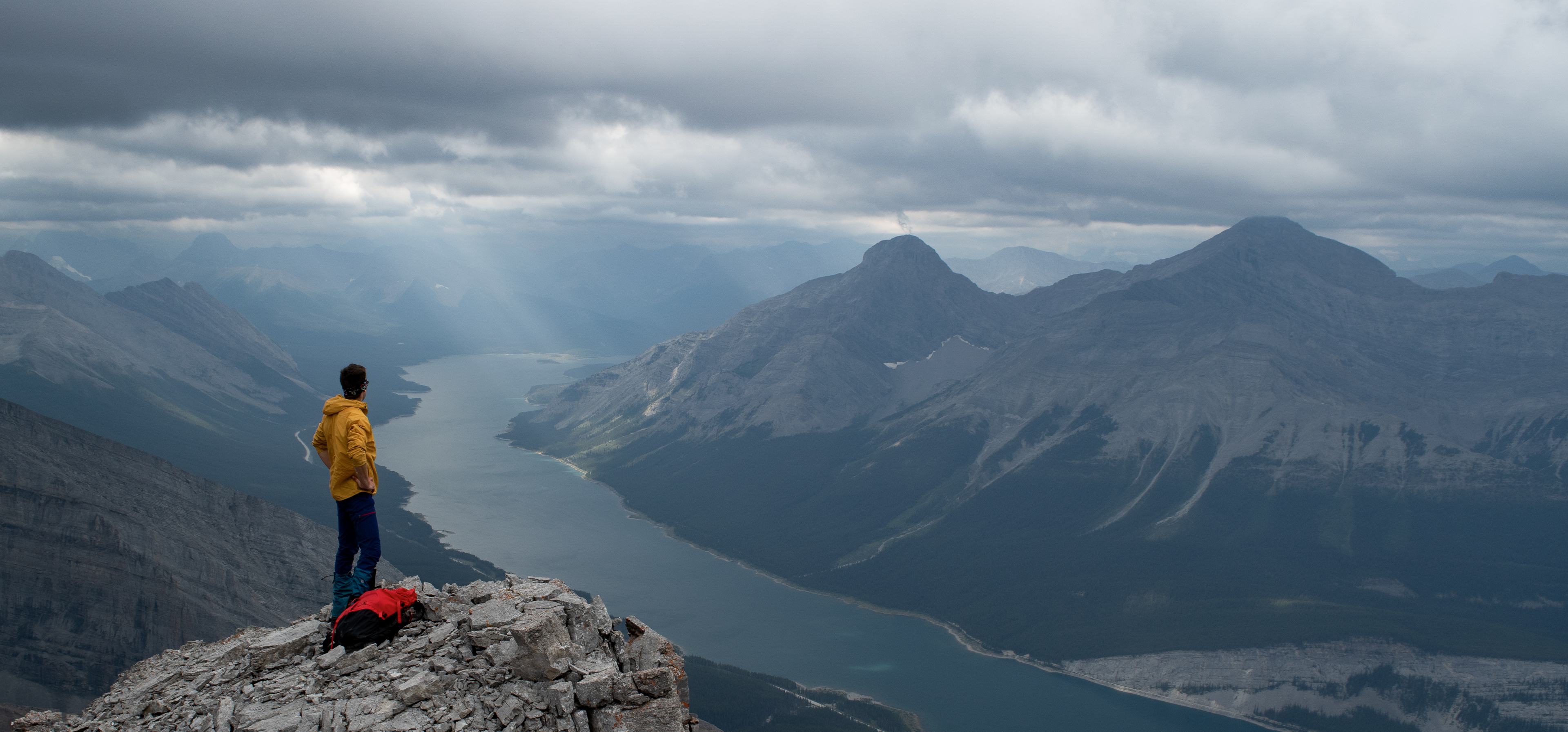
Sparrowhawk, seen descending Tower Three's south face
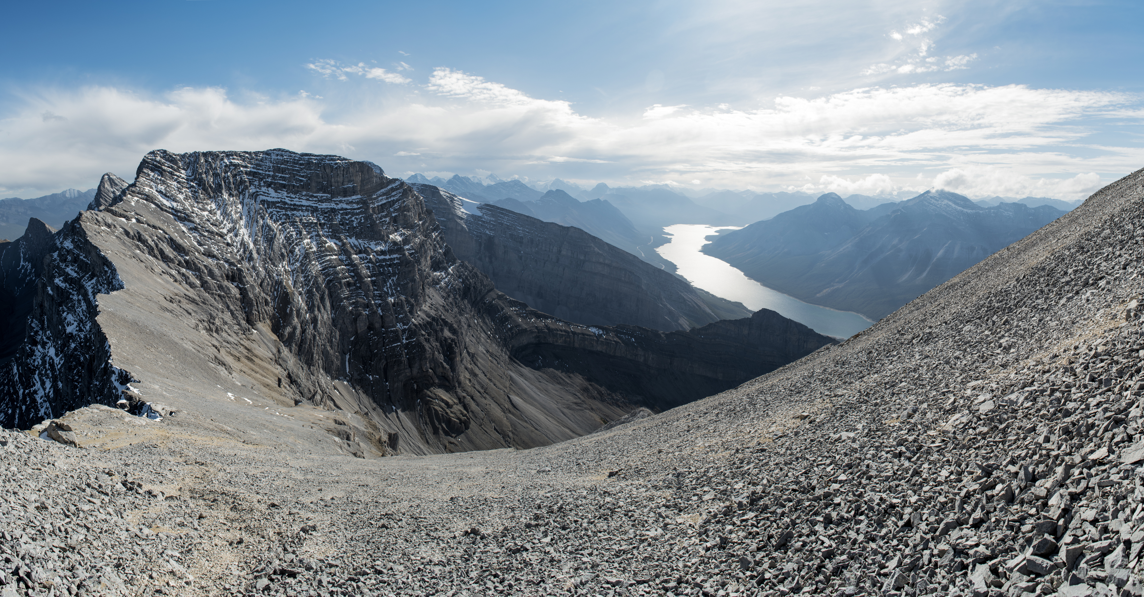
Sparrowhawk and a glimpse of the Spray Reservoir, from lower on Wind's north ridge. Assiniboine sits center frame on the horizon.
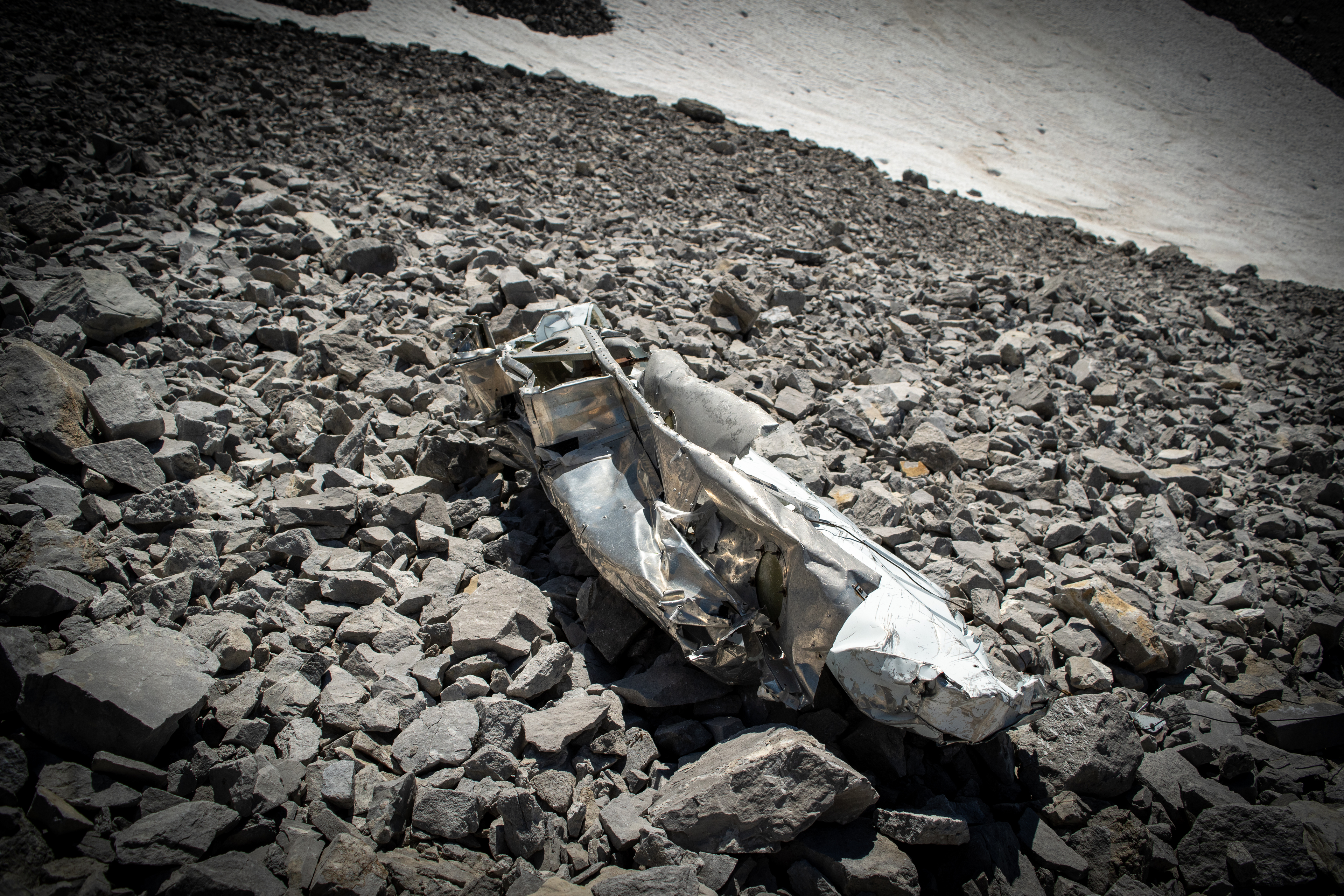
It’s a chunk of Bruce Pratt’s Cessna 185, snapped near the drainage between Lougheed's third tower and Wind Mountain a few weeks after the 31st anniversary of the crash. If you descend Lougheed's third tower by this route you'll walk right past the debris.
Bruce Pratt and two spotters, Rod Harrandance and Hayden Evans, lost their lives when their Cessna struck the mountain, right here, 1986 June 6. It was the first of two search-plane crashes over eight days that would end up claiming eleven lives, thirteen if we include the crash that started the search.
They used small, fixed wing aircraft for search and rescue then. It’s more helicopter now (improved helicopter technology?). They were looking for another downed aircraft (two died earlier that same day) and were followed by yet another aircraft (another eight died, eight days later on June 14).
It’s the “Memorial” in the nearby Memorial Lakes and has a commemorative plaque there. I was in grade school when it unfolded. It was the same year as Nasa’s Challenger crash and the Alberta Government engraved the same lines from Canadian pilot John Gillespie Magee Jr.’s “High Flight” that Ronald Regan spoke to address the Challenger tragedy.
It was a big deal at the time. My sympathy hasn’t diminished, not in the least, though my tolerance for the term “inherent risk” has.
The Alberta Aviation Museum has a page that treats this tragic tale well.
Compared to what's behind you, it's smooth sailing from here. So I think we'll wrap it up.
Just before do, you may recall my mentioning that some folks frown on the mountaineering practice of building cairns. It seems like a relatively recent thing to me — about as recent as "cancel culture". I have some thoughts on the matter (that was one).
In case you opt to skip my rant, I'll say "thanks" for reading my TR now! Hopefully there's some content here that adds to your experience, should you hike this fantastic traverse. If you do, I hope I've been able to offer something here that may help you see why it's a regular favourite of mine.
Cheers!
(from Emyn Muil, above)
I could see "no cairns" making sense in a busier mountain park where wardens watch and maintain the trails. I wouldn’t build a cairn on the West Rundle route from town, for example. Nor Cascade, Ha Ling, the hike to Sulphur Mountain’s upper terminal nor Corey Pass and so on. You get the idea.
But the Rundle Traverse? Goat Traverse? This thing?
Absolutely!
My first scrambles up Smuts in the 90s, even Temple’s southwest ridge, I remember what a relief it was to climb onto a ledge and spot a cairn. Or to hear a buddy call out that they'd found one. Of course, we've had GPS for some time now and there is no question that it's helpful. Yet it's not the same as a cairn, especially in busy, steep and technically demanding terrain where even a badly placed cairn is better than no cairn and relying on your GPS — even with your own track — works against you. That cairn, well-placed or not, is a physically grounded reference.
These aren’t popular trails (though Temple now is, while the buses run). More obscure approaches and ascents don’t have any trail. The Lougheed Traverse isn’t quite “obscure”, though it hardly qualifies as a “trail” in any sense similar to the nearby Windtower or Rimwall hikes.
In this context, cairns do more than make sense. They make it safer up here, and "no cairns" is a head-scratcher. Another idea that supposed to sound like it means well but doesn't, from folks who want to sound like they know better but don't. It's progressed itself off a cliff. I prefer to leave all that stuff back in town.
So I won’t tell you to build cairns. But I will. And I’ll appreciate it when you do.
If a cairn Karen doesn't like it, she can climb on up here and write me a ticket.
Page updated: 2025 Jan 28